Ages: Colin was 71 years and 306 days. Rosemary was 69 years and 83 days.
Weather: Mostly sunny, calm, and warm for the time of
year. Slight breeze in exposed places.
Location: Llanfairpwllgwyngyllgogerychrndrobyllllantysiliogogogoch to Caernarfon.
Distance: 10 miles.
Total distance: 3592 miles.
Terrain: Crossed Britannia Bridge. Some woodland — muddy! Mostly tarmacked cycleways. Slightly undulating.
Tide: Coming in.
Rivers: No.426, Menai Strait. No.427, Afon Seiont.
Ferries: None.
Piers: No.36 in Caernarfon. (A little one, only built in 1998!)
Kissing gates: Nos.672 and 673 at each end of a National Trust property.
Pubs: None.
‘Cadw’ properties: No.7, Caernarfon Castle.
Ferris wheels: None.
Diversions: No.80 in Caernarfon — we had to walk through the town because the waterfront was being repaired after storm damage.
How we got there and back: Two days ago we drove from home to a cosy little holiday cottage near Criccieth, the same one we stayed in last October. This morning we drove almost to Caernarfon, but didn’t cross the river because we could park for free on the other side. We then walked across a footbridge into the town, and caught a bus to Penrhos. We walked down a lane, then crossed the Britannia Bridge on to Anglesey. We then walked down to the church car park where we finished the last Walk back in October.
At the end we came to our car parked just across the river from Caernarfon town centre. We had our tea and chocolate biscuits, then returned to our cosy cottage.
We started today’s Walk where we finished the last one five months ago, in the car park by the church in Llanfairpwllgwyngyllgogerychrndrobyllllantysiliogogogoch. The weather was quite kind to us today, brilliant sunshine all the way.
 We saw snowdrops in the woods by the car park, always a cheery sight at
this time of year. Spring is on its
way! We walked up to the main road and
left the village with the longest name in Britain. I’m trying to learn how to pronounce it, but it’s
not easy.
We saw snowdrops in the woods by the car park, always a cheery sight at
this time of year. Spring is on its
way! We walked up to the main road and
left the village with the longest name in Britain. I’m trying to learn how to pronounce it, but it’s
not easy.

 We donned our high-viz vests and crossed the Britannia
Bridge back on to mainland Wales. The road was very busy, the traffic was constant. There was a sort-of pavement for us, but it
was very narrow when it went through the arches. Obviously pedestrians are not encouraged to
use this bridge but nobody said we couldn’t.
We were relieved to get to the other side. We could see along the Menai Strait
from up high, the Nelson statue on its plinth and lion statues either side (we
could see these better when we were down the bottom).
We donned our high-viz vests and crossed the Britannia
Bridge back on to mainland Wales. The road was very busy, the traffic was constant. There was a sort-of pavement for us, but it
was very narrow when it went through the arches. Obviously pedestrians are not encouraged to
use this bridge but nobody said we couldn’t.
We were relieved to get to the other side. We could see along the Menai Strait
from up high, the Nelson statue on its plinth and lion statues either side (we
could see these better when we were down the bottom).


We crossed the road with difficulty, and removed our high-viz vests. We then followed a concrete track which led down underneath the bridge. We came to where the railway turns on to the bridge, it runs underneath the road. We went down further and looked at the lion statues which are ‘holding up’ the bridge — or else guarding it!

 Down further we came across a section of the original bridge set in
concrete as an exhibit. There was also
the history of the bridge on a board.
Further down still we passed the remains of a jack which fractured
during the construction of the original bridge killing several workers. The track came to a dead end by the river
where we strongly suspect a ferry across the strait was situated in
yesteryear. We went back up to where the
history board was, and finding nowhere else to sit down we perched ourselves on
the concrete plinth of the section to eat our pies.
Down further we came across a section of the original bridge set in
concrete as an exhibit. There was also
the history of the bridge on a board.
Further down still we passed the remains of a jack which fractured
during the construction of the original bridge killing several workers. The track came to a dead end by the river
where we strongly suspect a ferry across the strait was situated in
yesteryear. We went back up to where the
history board was, and finding nowhere else to sit down we perched ourselves on
the concrete plinth of the section to eat our pies.
 The history of the Britannia
Bridge is this. Until 1970 it was just a railway bridge with
no road. It was built by Robert
Stephenson in 1850 to connect Chester
with Holyhead. It was a tubular bridge
built of wrought iron rectangular box-section spans. This design was an innovation in the 19th
century, it had never been used before.
The bridge had to be high enough to allow the tall ships of the day to
pass underneath, but also strong enough to carry heavy steam locomotives across
the distance. Stephenson, in conjunction
with William Fairbairn, tried out his design at Conwy, a much shorter span over
the River Conwy next to the castle. He
wanted to confirm through testing that the structure, the first tubular
crossing to be built, would be capable of carrying the weight of a locomotive
and its rolling stock. The successful results in 1848 endorsed the construction
of the Britannia Bridge.
The history of the Britannia
Bridge is this. Until 1970 it was just a railway bridge with
no road. It was built by Robert
Stephenson in 1850 to connect Chester
with Holyhead. It was a tubular bridge
built of wrought iron rectangular box-section spans. This design was an innovation in the 19th
century, it had never been used before.
The bridge had to be high enough to allow the tall ships of the day to
pass underneath, but also strong enough to carry heavy steam locomotives across
the distance. Stephenson, in conjunction
with William Fairbairn, tried out his design at Conwy, a much shorter span over
the River Conwy next to the castle. He
wanted to confirm through testing that the structure, the first tubular
crossing to be built, would be capable of carrying the weight of a locomotive
and its rolling stock. The successful results in 1848 endorsed the construction
of the Britannia Bridge.
 It was in regular use for the next 120 years. In 1970 a group of teenage boys were playing
underneath. They lit a camp fire, and a
burning torch accidentally set alight the tar-coated wooden roof of the
tubes. The fire spread rapidly along the
whole length of the bridge. The boys
were devastated — they never intended to do any damage. Fire brigades from all around were called,
but due to the bridge’s height, construction, location and lack of adequate
water supply they could do little except allow the fire to spectacularly burn
itself out. Afterwards the bridge was
still standing, but the structural integrity of the iron tubes had been
critically compromised by the intense heat.
It was in regular use for the next 120 years. In 1970 a group of teenage boys were playing
underneath. They lit a camp fire, and a
burning torch accidentally set alight the tar-coated wooden roof of the
tubes. The fire spread rapidly along the
whole length of the bridge. The boys
were devastated — they never intended to do any damage. Fire brigades from all around were called,
but due to the bridge’s height, construction, location and lack of adequate
water supply they could do little except allow the fire to spectacularly burn
itself out. Afterwards the bridge was
still standing, but the structural integrity of the iron tubes had been
critically compromised by the intense heat.
 It was essential to get the railway link reopened as soon as was
possible. The remains of Stephenson’s
box bridge were demolished leaving the original stone substructure which was
scorched but undamaged. The 20th
century bridge which replaced it is of a different construction. Initially it
was a single tier steel truss arch bridge to carry the railway only. But by 1980 it was realised that Telford’s
suspension bridge was inadequate to carry the volumes of traffic now crossing
daily over the Menai Strait to and from Anglesey. So a second tier was added to the Britannia Bridge,
“upstairs” above the railway, so that the busy A55 could be diverted across it
relieving the pressure on the Menai
Bridge.
It was essential to get the railway link reopened as soon as was
possible. The remains of Stephenson’s
box bridge were demolished leaving the original stone substructure which was
scorched but undamaged. The 20th
century bridge which replaced it is of a different construction. Initially it
was a single tier steel truss arch bridge to carry the railway only. But by 1980 it was realised that Telford’s
suspension bridge was inadequate to carry the volumes of traffic now crossing
daily over the Menai Strait to and from Anglesey. So a second tier was added to the Britannia Bridge,
“upstairs” above the railway, so that the busy A55 could be diverted across it
relieving the pressure on the Menai
Bridge.
 There were no footpaths marked on our OS map leading from the site where
we were sitting, so we were pleased to see a Coastal Path sign pointing off
into the woods. It meant we didn’t have
to walk along the busy main road.
Yesterday we had reccied this spot and found a Road Closed sign blocking
this path. But it was gone today, so we
were pleased. (We were going to ignore
it anyway in our inimitable way!)
There were no footpaths marked on our OS map leading from the site where
we were sitting, so we were pleased to see a Coastal Path sign pointing off
into the woods. It meant we didn’t have
to walk along the busy main road.
Yesterday we had reccied this spot and found a Road Closed sign blocking
this path. But it was gone today, so we
were pleased. (We were going to ignore
it anyway in our inimitable way!)
 The path was good at first but like many paths we have walked, it quickly
deteriorated. It became uneven and
muddy. I tripped on a tree stump hidden
under leaves — I was not hurt, I just got a wet bum! Colin started to pull me up but I got cramp
in my legs as he did so and staggered about in agony for a couple of
minutes. We were astounded that such a
hidden stump had been left in the middle of the path. Initially we were alongside the Strait — we
could see the Britannia
Bridge behind us and
Nelson’s statue across the water. Then
we were turned more inland, deeper into the woods.
The path was good at first but like many paths we have walked, it quickly
deteriorated. It became uneven and
muddy. I tripped on a tree stump hidden
under leaves — I was not hurt, I just got a wet bum! Colin started to pull me up but I got cramp
in my legs as he did so and staggered about in agony for a couple of
minutes. We were astounded that such a
hidden stump had been left in the middle of the path. Initially we were alongside the Strait — we
could see the Britannia
Bridge behind us and
Nelson’s statue across the water. Then
we were turned more inland, deeper into the woods.
 We passed through a wrought iron gate in a stone wall as we crossed into
National Trust property. There the trees
were closer together. There had been a
lot of work recently done in this wood — was that the reason for the Road
Closed notice we had seen yesterday?
Conifer branches had been thrown down on the muddiest sections of the
path, and they helped a little. The path
climbed steeply, then we came to a stony track where a logo arrow told us to
turn sharply back, seemingly in the “wrong” direction. There was a log across the track in the
“right” direction with a lot of brushwood which would have been difficult to
pass. So we followed the logo. The track continued to climb, but as it did
so it curved round until we were walking
in the “right” direction after all.
We passed through a wrought iron gate in a stone wall as we crossed into
National Trust property. There the trees
were closer together. There had been a
lot of work recently done in this wood — was that the reason for the Road
Closed notice we had seen yesterday?
Conifer branches had been thrown down on the muddiest sections of the
path, and they helped a little. The path
climbed steeply, then we came to a stony track where a logo arrow told us to
turn sharply back, seemingly in the “wrong” direction. There was a log across the track in the
“right” direction with a lot of brushwood which would have been difficult to
pass. So we followed the logo. The track continued to climb, but as it did
so it curved round until we were walking
in the “right” direction after all.
 We passed a mausoleum deep in the woods.
It looked vandalised and neglected with broken windows and tall trees
growing up around it. It was a forlorn
sight, rather sad. A notice on the door
said, “PRIVATE Legal action will be
taken against unauthorised persons found on this property”. It didn’t look as if anyone had been “found” on the property for the past
hundred years!
We passed a mausoleum deep in the woods.
It looked vandalised and neglected with broken windows and tall trees
growing up around it. It was a forlorn
sight, rather sad. A notice on the door
said, “PRIVATE Legal action will be
taken against unauthorised persons found on this property”. It didn’t look as if anyone had been “found” on the property for the past
hundred years!
 After that the track was straight to the edge of the wood where we passed
through a brand new kissing gate. The
logo arrows told us to take a short cut across a field of sheep, but we noticed
that the logo arrows for walkers in the opposite direction pointed them to go
round the edge! We went up through a
glade of early daffodils to a picnic area.
It was all very pretty, but too early to stop for lunch.
After that the track was straight to the edge of the wood where we passed
through a brand new kissing gate. The
logo arrows told us to take a short cut across a field of sheep, but we noticed
that the logo arrows for walkers in the opposite direction pointed them to go
round the edge! We went up through a
glade of early daffodils to a picnic area.
It was all very pretty, but too early to stop for lunch.
 After that there were no logos! Absolutely nothing to tell us which
way the official Wales Coast Path continued.
So we followed the road which took us uphill and seemed to be curving
back the way we had come.
After that there were no logos! Absolutely nothing to tell us which
way the official Wales Coast Path continued.
So we followed the road which took us uphill and seemed to be curving
back the way we had come.
 Every possible
turning to the right was labelled Private. We were nearly up to the main road when Colin
found a disused road blocked to traffic by large rocks. We went up there thinking we would be able to
get round the rocks on foot, but we still couldn’t get on to the road. We had to divert round a Premier Inn before
we managed to escape.
Every possible
turning to the right was labelled Private. We were nearly up to the main road when Colin
found a disused road blocked to traffic by large rocks. We went up there thinking we would be able to
get round the rocks on foot, but we still couldn’t get on to the road. We had to divert round a Premier Inn before
we managed to escape.
We crossed the main road, which was difficult because there was no central reservation. We both felt angry and let down because we’d walked in a big circle and, after two hours, we were almost back where we had started!
 If it
was any consolation (it wasn’t) we had good views of Snowdonia with patches of
snow from that roadside. We could pick
out Snowdon by its characteristic shape and,
through our binoculars / telescope, we could even make out the summit
railway. We were convinced we had lost
the Wales Coast Path, but we hadn’t because at the next roundabout there were
the logos!
If it
was any consolation (it wasn’t) we had good views of Snowdonia with patches of
snow from that roadside. We could pick
out Snowdon by its characteristic shape and,
through our binoculars / telescope, we could even make out the summit
railway. We were convinced we had lost
the Wales Coast Path, but we hadn’t because at the next roundabout there were
the logos!
 There was a slate sculpture each side of a cycleway near the
roundabout. We turned on to a B road and
passed the grand gates of the estate we’d just walked through, but hadn’t been
allowed to go in the direction we’d wanted.
The B road was busy, so we decided to follow cycle path logos on to the
Llanberis road, then take a “yellow” road parallel to the B road (the walkers’
Wales Coast Path logos had disappeared again — we were getting a bit fed up
with this). A cycleway forked off the
road to the right, so we followed this.
Then the cycleway itself forked and there were no logos. We chose the right hand one because it was
nearer the sea. It took us along an old
railway track through a cutting.
There was a slate sculpture each side of a cycleway near the
roundabout. We turned on to a B road and
passed the grand gates of the estate we’d just walked through, but hadn’t been
allowed to go in the direction we’d wanted.
The B road was busy, so we decided to follow cycle path logos on to the
Llanberis road, then take a “yellow” road parallel to the B road (the walkers’
Wales Coast Path logos had disappeared again — we were getting a bit fed up
with this). A cycleway forked off the
road to the right, so we followed this.
Then the cycleway itself forked and there were no logos. We chose the right hand one because it was
nearer the sea. It took us along an old
railway track through a cutting.
 At the
end it went under the main road, and we thought we would be able to get down to
the dock at Y Felinheli from there — but we were thwarted by tall iron
bars! It struck us that this section of
the Wales Coast Path needs to be thought out again.
At the
end it went under the main road, and we thought we would be able to get down to
the dock at Y Felinheli from there — but we were thwarted by tall iron
bars! It struck us that this section of
the Wales Coast Path needs to be thought out again.
 We backtracked a little so we could sit on some steps and eat our
sarnies. An old man with a basset hound
staggered along and stopped for a chat.
His Welsh accent was so strong we had difficulty in understanding him,
so we went along with his well-meaning advice about our route although we
didn’t know what he was on about. It was
easier that way. He said the dog was
only eighteen months old though it looked obese and out of condition to
us. He told us his granddaughter had
bought it for £500!!
We backtracked a little so we could sit on some steps and eat our
sarnies. An old man with a basset hound
staggered along and stopped for a chat.
His Welsh accent was so strong we had difficulty in understanding him,
so we went along with his well-meaning advice about our route although we
didn’t know what he was on about. It was
easier that way. He said the dog was
only eighteen months old though it looked obese and out of condition to
us. He told us his granddaughter had
bought it for £500!!
Finishing our lunch, we took some steps up to another cycleway and went out to the B road—it seemed to be the only way we could get out. Further along we saw Wales Coast Path logos pointing up into a wood. Should we have come out from there? How? Where did we lose it? We were above the dock inlet of Y Felinheli, and we puzzled as to where the sea was because the Menai Strait is quite narrow at that point. Perhaps we were tired, but we couldn’t quite work it out.
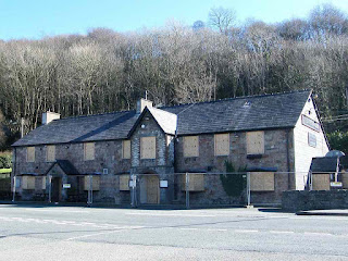 We crossed the road in front of a large pub where every window and door
was boarded up — a sad sight. We turned
off the main road and walked by the dock.
We crossed the road in front of a large pub where every window and door
was boarded up — a sad sight. We turned
off the main road and walked by the dock.
 We passed a lifting bridge and lock gates.
 We walked round the marina, and then past
loads of empty buoys for summer visitors — Colin counted over fifty.
We walked round the marina, and then past
loads of empty buoys for summer visitors — Colin counted over fifty.
 We went down on to a slatey beach which was
easy to walk on because the flat stones don’t roll around.
We went down on to a slatey beach which was
easy to walk on because the flat stones don’t roll around.
 We met a swan with two surviving
almost-grownup young from last year.
We met a swan with two surviving
almost-grownup young from last year.
 We left Y Felinheli on a cycleway which took us all the way to Caernarfon
— a bit boring really, but at least we were off-road.
We left Y Felinheli on a cycleway which took us all the way to Caernarfon
— a bit boring really, but at least we were off-road.

 We went under a farmtrack bridge where the
ivy had loosened the brickwork and brought some of it down next to the
path. There was soot still on the
underside of the bridge from when this cycleway was a railway — Colin knocked
some off to confirm this. We stopped at
a picnic table to eat our chocolate. I
was feeling very tired, and decided I wasn’t as fit as I would like to have
been. I must admit I didn’t do much
walking over the winter — oh dear!
We went under a farmtrack bridge where the
ivy had loosened the brickwork and brought some of it down next to the
path. There was soot still on the
underside of the bridge from when this cycleway was a railway — Colin knocked
some off to confirm this. We stopped at
a picnic table to eat our chocolate. I
was feeling very tired, and decided I wasn’t as fit as I would like to have
been. I must admit I didn’t do much
walking over the winter — oh dear!
 In a field opposite there were numerous molehills. They looked very fresh, bet there were a lot
of moles digging there. I’ve never seen
a mole, and Colin has only ever seen a dead one. But we have seen molehills moving as the
animals dug underneath. Further along
there were sculptures of giant seashells in a field — we must be getting near
the sea again.
In a field opposite there were numerous molehills. They looked very fresh, bet there were a lot
of moles digging there. I’ve never seen
a mole, and Colin has only ever seen a dead one. But we have seen molehills moving as the
animals dug underneath. Further along
there were sculptures of giant seashells in a field — we must be getting near
the sea again.
 It seemed a long long
walk! As we neared Caernarfon we met
more and more dog-walkers ambling along.
We couldn’t understand the significance of a slate standing circle, was
it a memorial of some kind?
It seemed a long long
walk! As we neared Caernarfon we met
more and more dog-walkers ambling along.
We couldn’t understand the significance of a slate standing circle, was
it a memorial of some kind?

 On entering the town we diverted to Morrison’s to use the toilet. We returned to exactly the same spot on the
waterfront and carried on feeling much more comfortable. We walked on a little wooden pier in front of
some flats — it was only constructed in 1998, very modern.
On entering the town we diverted to Morrison’s to use the toilet. We returned to exactly the same spot on the
waterfront and carried on feeling much more comfortable. We walked on a little wooden pier in front of
some flats — it was only constructed in 1998, very modern.
 On the quayside there was an old crane which
used to be used for unloading ships. We
passed the marina full of luxury yachts.
The occasional flagstone was chequered, which added interest to our
stroll — for we were only strolling by now.
One boasted the word Polska, so we assumed it was
designed by Polish people.
On the quayside there was an old crane which
used to be used for unloading ships. We
passed the marina full of luxury yachts.
The occasional flagstone was chequered, which added interest to our
stroll — for we were only strolling by now.
One boasted the word Polska, so we assumed it was
designed by Polish people.

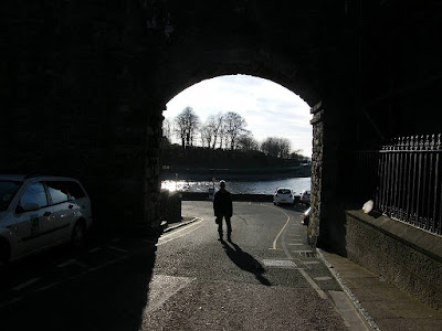
 The footpath round the waterfront under the castle walls was closed
because it was being improved before the summer season, so we had to divert
through the town. Caernarfon is a walled
medieval town, so we had to enter through an imposing gateway. We passed some posts leaning at a steep
angle, had they been hit by a lorry? We
walked along next to the intimidating castle walls, and out through a tunnel to
the riverside.
The footpath round the waterfront under the castle walls was closed
because it was being improved before the summer season, so we had to divert
through the town. Caernarfon is a walled
medieval town, so we had to enter through an imposing gateway. We passed some posts leaning at a steep
angle, had they been hit by a lorry? We
walked along next to the intimidating castle walls, and out through a tunnel to
the riverside.
 We then crossed the river
on a footbridge to our car which was parked on the other side.
We then crossed the river
on a footbridge to our car which was parked on the other side.

That ended Walk no.348, we shall pick up Walk no.349 next time on the south side of the river by Caernarfon Castle. It was twenty-five to five, so the Walk had taken us six hours forty minutes. We had our tea and chocolate biscuits, then returned to our cosy cottage.
Location: Llanfairpwllgwyngyllgogerychrndrobyllllantysiliogogogoch to Caernarfon.
Distance: 10 miles.
Total distance: 3592 miles.
Terrain: Crossed Britannia Bridge. Some woodland — muddy! Mostly tarmacked cycleways. Slightly undulating.
Tide: Coming in.
Rivers: No.426, Menai Strait. No.427, Afon Seiont.
Ferries: None.
Piers: No.36 in Caernarfon. (A little one, only built in 1998!)
Kissing gates: Nos.672 and 673 at each end of a National Trust property.
Pubs: None.
‘Cadw’ properties: No.7, Caernarfon Castle.
Ferris wheels: None.
Diversions: No.80 in Caernarfon — we had to walk through the town because the waterfront was being repaired after storm damage.
How we got there and back: Two days ago we drove from home to a cosy little holiday cottage near Criccieth, the same one we stayed in last October. This morning we drove almost to Caernarfon, but didn’t cross the river because we could park for free on the other side. We then walked across a footbridge into the town, and caught a bus to Penrhos. We walked down a lane, then crossed the Britannia Bridge on to Anglesey. We then walked down to the church car park where we finished the last Walk back in October.
At the end we came to our car parked just across the river from Caernarfon town centre. We had our tea and chocolate biscuits, then returned to our cosy cottage.
We started today’s Walk where we finished the last one five months ago, in the car park by the church in Llanfairpwllgwyngyllgogerychrndrobyllllantysiliogogogoch. The weather was quite kind to us today, brilliant sunshine all the way.


We crossed the road with difficulty, and removed our high-viz vests. We then followed a concrete track which led down underneath the bridge. We came to where the railway turns on to the bridge, it runs underneath the road. We went down further and looked at the lion statues which are ‘holding up’ the bridge — or else guarding it!


We crossed the main road, which was difficult because there was no central reservation. We both felt angry and let down because we’d walked in a big circle and, after two hours, we were almost back where we had started!


Finishing our lunch, we took some steps up to another cycleway and went out to the B road—it seemed to be the only way we could get out. Further along we saw Wales Coast Path logos pointing up into a wood. Should we have come out from there? How? Where did we lose it? We were above the dock inlet of Y Felinheli, and we puzzled as to where the sea was because the Menai Strait is quite narrow at that point. Perhaps we were tired, but we couldn’t quite work it out.


That ended Walk no.348, we shall pick up Walk no.349 next time on the south side of the river by Caernarfon Castle. It was twenty-five to five, so the Walk had taken us six hours forty minutes. We had our tea and chocolate biscuits, then returned to our cosy cottage.
The Welsh Highland
Railway


Caernarfon Castle


No comments:
Post a Comment