Ages: Colin was 71 years and 308 days. Rosemary was 69 years and 85 days.
Weather: Sunny.
Calm. Wall-to-wall blue sky. Slight breeze by the coast. Fog appeared mid-afternoon turning it
considerably colder.
Location: Caernarfon to Clynnog Fawr.
Distance: 14 miles.
Total distance: 3606 miles.
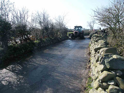
Terrain: Mostly roads and cycleways. One footpath across farmland which ended with me being rescued by tractor from ankle-deep slurry! (Pooh!!)
Tide: Out.
Rivers: No.428, Afon Gwyrfai. No.429, Afon Carrog.
Ferries: None.
Piers: None.
Kissing gates: Nos.674 (it was bust!) and 675 at each end of a marsh.
Pubs: None.
‘Cadw’ properties: None.
Ferris wheels: None.
Diversions: None.
How we got there and back: We were staying in a holiday cottage near Criccieth. This morning we drove to Clynnog Fawr and parked in a residential street. We walked down to the village bus stop and caught a bus to Caernarfon.
At the end we walked into the village and turned up the road where our car was parked. We had our tea and chocolate biscuits, then returned to our cottage.
 It was beautiful weather as we started today’s Walk,
wall-to-wall blue sky and no wind. The
water on Afon Seiont was like a millpond with lovely reflections. It was so peaceful and quiet. We had originally planned to come and do
these Walks next week, but we hadn’t booked the cottage and when we heard there
was likely to be high pressure hanging over the British
Isles all this week we decided to come a week early. Luckily the cottage was available. It was not only the weather that was in our
favour — this morning there was a notice on the footbridge we had crossed over
from Caernarfon saying that they plan to close it next Monday “to allow major
maintenance work on the bridge”. So if
we had come next week we would have had difficulty getting across.
It was beautiful weather as we started today’s Walk,
wall-to-wall blue sky and no wind. The
water on Afon Seiont was like a millpond with lovely reflections. It was so peaceful and quiet. We had originally planned to come and do
these Walks next week, but we hadn’t booked the cottage and when we heard there
was likely to be high pressure hanging over the British
Isles all this week we decided to come a week early. Luckily the cottage was available. It was not only the weather that was in our
favour — this morning there was a notice on the footbridge we had crossed over
from Caernarfon saying that they plan to close it next Monday “to allow major
maintenance work on the bridge”. So if
we had come next week we would have had difficulty getting across.

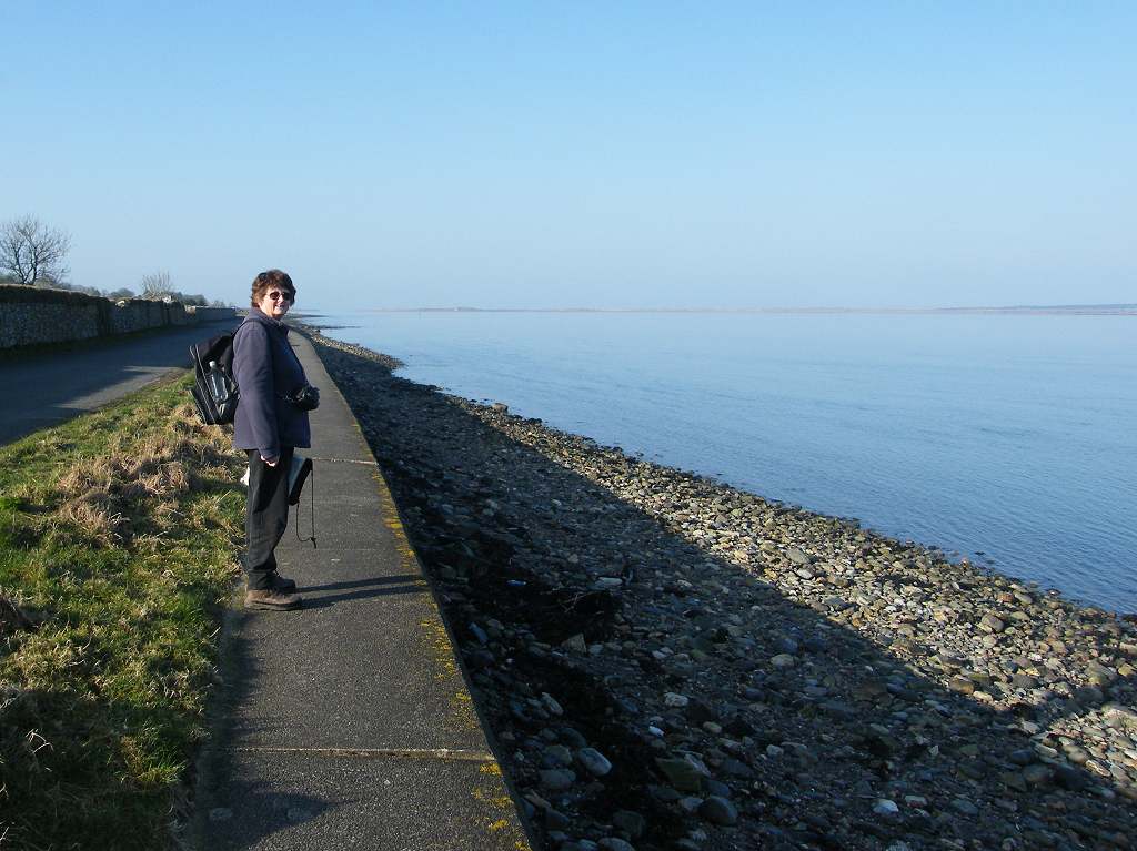
 We had a lovely lazy walk alongside the Menai Strait. There was hardly any traffic and few people —
just the occasional dog-walker. There
was no sound of traffic when one of the dog-walkers stopped for a chat. He asked, “Are you enjoying the
tranquillity?” We laughed and answered,
“Yes, except for that wretched microlight which keeps buzzing around!”
We had a lovely lazy walk alongside the Menai Strait. There was hardly any traffic and few people —
just the occasional dog-walker. There
was no sound of traffic when one of the dog-walkers stopped for a chat. He asked, “Are you enjoying the
tranquillity?” We laughed and answered,
“Yes, except for that wretched microlight which keeps buzzing around!”

 We stopped at a picnic site to eat our
pasties. There was evidence that the sea
had recently been up over the road — seaweed was draped on the hedge on the far
side! We could see Snowdonia in the
distance, and spied some herons by a pond in a field.
We stopped at a picnic site to eat our
pasties. There was evidence that the sea
had recently been up over the road — seaweed was draped on the hedge on the far
side! We could see Snowdonia in the
distance, and spied some herons by a pond in a field.

 A little further on we had to turn away from the coast in
order to cross a river. We came out on
to a slightly mainer road and crossed the bridge. The Wales Coast Path went straight on from
there, and we thought it then turned inland because, frustratingly, the route
of it was not marked on our fairly new OS map.
We turned directly on to a public footpath which ran back to the coast alongside
the river. (We were to regret that decision later.)
A little further on we had to turn away from the coast in
order to cross a river. We came out on
to a slightly mainer road and crossed the bridge. The Wales Coast Path went straight on from
there, and we thought it then turned inland because, frustratingly, the route
of it was not marked on our fairly new OS map.
We turned directly on to a public footpath which ran back to the coast alongside
the river. (We were to regret that decision later.)

 It was a good track as far as a house, then
it got a bit muddy — but we coped. It
was OK across some fields but tended to be very muddy around gateways where the
animals like to congregate. We felt a
bit sorry for some horses in a field we passed where they had no grass, only
mud.
It was a good track as far as a house, then
it got a bit muddy — but we coped. It
was OK across some fields but tended to be very muddy around gateways where the
animals like to congregate. We felt a
bit sorry for some horses in a field we passed where they had no grass, only
mud.
 We got to the last gate before the farm, and on the other
side of it the track was ankle-deep in farm slurry! It was wall-to-wall, and horrible! It looked solid, but it was very liquid. There was no getting away from it, so we
started paddling through. Colin was
ahead of me. He tried tiptoe and yelled
back, “It’s deeper at this end!” He’d got it inside his boots by then, but I
hadn’t quite. I saw a narrow bank next
to the opposite wall, so I paddled across and hauled myself up on to it. But it was soft and started giving way — and
it petered out a few yards ahead anyway.
I still had about fifty yards to go, and I was stuck!
We got to the last gate before the farm, and on the other
side of it the track was ankle-deep in farm slurry! It was wall-to-wall, and horrible! It looked solid, but it was very liquid. There was no getting away from it, so we
started paddling through. Colin was
ahead of me. He tried tiptoe and yelled
back, “It’s deeper at this end!” He’d got it inside his boots by then, but I
hadn’t quite. I saw a narrow bank next
to the opposite wall, so I paddled across and hauled myself up on to it. But it was soft and started giving way — and
it petered out a few yards ahead anyway.
I still had about fifty yards to go, and I was stuck!
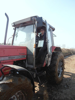 By then the farmer had come out, though I could see neither
him nor Colin from my position on the disintegrating bank. Colin yelled, “The farmer’s coming for you with his tractor!” And so he did, like a knight in shining
armour, his tractor wheels making waves in the slurry! I had to extricate myself from a persistent
bramble loop before I could step on to the metal footplate and get in the
tractor. Then I was ferried to the end
of the slurry.
By then the farmer had come out, though I could see neither
him nor Colin from my position on the disintegrating bank. Colin yelled, “The farmer’s coming for you with his tractor!” And so he did, like a knight in shining
armour, his tractor wheels making waves in the slurry! I had to extricate myself from a persistent
bramble loop before I could step on to the metal footplate and get in the
tractor. Then I was ferried to the end
of the slurry.
 The farmer was apologetic for leaving the track like that,
but said it had been very wet these recent weeks and there was nothing he could
do. He took us into a barn where there
was a hosepipe and lent us a coarse brush.
So we were able to clean off our filthy boots, but Colin had some slurry
inside his which was most uncomfortable, and smelly! I had it splashed up my trousers.
The farmer was apologetic for leaving the track like that,
but said it had been very wet these recent weeks and there was nothing he could
do. He took us into a barn where there
was a hosepipe and lent us a coarse brush.
So we were able to clean off our filthy boots, but Colin had some slurry
inside his which was most uncomfortable, and smelly! I had it splashed up my trousers.
 The farmer told us he was very worried about his 83year old
father, with whom he ran the farm, who had just started a course of
chemotherapy for bowel cancer. Now, he
shouldn’t have let the slurry run out like that, especially on to a public
footpath. And if it did so, he should
have at least put up a notice at the beginning of the track informing walkers
of the situation. But we got the
impression that here was a very worried man who couldn’t cope anymore. Sad!
The farmer told us he was very worried about his 83year old
father, with whom he ran the farm, who had just started a course of
chemotherapy for bowel cancer. Now, he
shouldn’t have let the slurry run out like that, especially on to a public
footpath. And if it did so, he should
have at least put up a notice at the beginning of the track informing walkers
of the situation. But we got the
impression that here was a very worried man who couldn’t cope anymore. Sad!
 We left the farm and turned on to a road. (We would have stayed on the road if we’d
known about the slurry, it was only two sides of a triangle instead of
one.) Further on we turned on to a
footpath over the marshes. We were
surprised to find it was signposted “Wales Coast
Path”. So, if we’d followed the
signposts at the river bridge and stayed on the road, we would have missed out
the slurry and been on the Wales Coast Path all the time — hindsight is a
wonderful thing! It was a good path
through trees, then over a solid footbridge.
The path across the marsh was on a high bank, so we had no problem with
mud.
We left the farm and turned on to a road. (We would have stayed on the road if we’d
known about the slurry, it was only two sides of a triangle instead of
one.) Further on we turned on to a
footpath over the marshes. We were
surprised to find it was signposted “Wales Coast
Path”. So, if we’d followed the
signposts at the river bridge and stayed on the road, we would have missed out
the slurry and been on the Wales Coast Path all the time — hindsight is a
wonderful thing! It was a good path
through trees, then over a solid footbridge.
The path across the marsh was on a high bank, so we had no problem with
mud.

 We turned on to a road which passed a small airport. We were trying to think of excuses as to why
we didn’t walk all round the airport to the tip of the sandspit, but we
couldn’t think of any except that we felt too lazy! There were small planes landing and taking
off as we walked past, and a couple of helicopters sat on the tarmac. The fence alongside the garden of a house on
the opposite side of the road was down.
That was due to high winds which we all experienced last week — this is
a very exposed spot. No wind today
though, the weather was perfect!
We turned on to a road which passed a small airport. We were trying to think of excuses as to why
we didn’t walk all round the airport to the tip of the sandspit, but we
couldn’t think of any except that we felt too lazy! There were small planes landing and taking
off as we walked past, and a couple of helicopters sat on the tarmac. The fence alongside the garden of a house on
the opposite side of the road was down.
That was due to high winds which we all experienced last week — this is
a very exposed spot. No wind today
though, the weather was perfect!
 At the end of the road we came to a car park with a picnic
table, so we sat there and ate our sarnies.
We had walked 3600 miles along the coast since leaving Bognor back in
1998, so we took a photo of ourselves using the delayed shutter.
At the end of the road we came to a car park with a picnic
table, so we sat there and ate our sarnies.
We had walked 3600 miles along the coast since leaving Bognor back in
1998, so we took a photo of ourselves using the delayed shutter.
 We could see a lighthouse on Anglesey from there.

 The Wales Coast Path continued due south, but there was a sandy beach
which we couldn’t resist. It was
absolute bliss to walk on — we both agreed that this was the best part of
today’s Walk! Eventually rocks forced us
up on to the prom which ended at Dinas Dinlle.
There we sat at a picnic table to eat our apples.
The Wales Coast Path continued due south, but there was a sandy beach
which we couldn’t resist. It was
absolute bliss to walk on — we both agreed that this was the best part of
today’s Walk! Eventually rocks forced us
up on to the prom which ended at Dinas Dinlle.
There we sat at a picnic table to eat our apples.

 There were no Wales Coast Path signs to be seen. There was no path continuing along the coast
and the beach was impossible. So we had
to follow the road which led inland. When
the pavement ran out, which it did pretty soon, we donned our high-viz
waistcoats. We really needed them on
this twisting narrow road even though there wasn’t much traffic. We passed a field with brown sheep — are they a rare breed? — and a tree bent
right over with the wind.
There were no Wales Coast Path signs to be seen. There was no path continuing along the coast
and the beach was impossible. So we had
to follow the road which led inland. When
the pavement ran out, which it did pretty soon, we donned our high-viz
waistcoats. We really needed them on
this twisting narrow road even though there wasn’t much traffic. We passed a field with brown sheep — are they a rare breed? — and a tree bent
right over with the wind.
 When we
reached the main road, we saw a Wales Coast Path sign opposite — we had been on
it all the time! It was a bit of a route-march from then on. We were relieved we didn’t have to
traffic-dodge because there was a cycleway alongside the main road. Much of the cycleway was “old road”,
separated from the noise of traffic by a row of trees. We liked this, and we got mildly annoyed when
we came to a stretch of this “old road” which was blocked by tree branches,
forcing us to walk on the new cycleway right next to the noisy and speeding
traffic.
When we
reached the main road, we saw a Wales Coast Path sign opposite — we had been on
it all the time! It was a bit of a route-march from then on. We were relieved we didn’t have to
traffic-dodge because there was a cycleway alongside the main road. Much of the cycleway was “old road”,
separated from the noise of traffic by a row of trees. We liked this, and we got mildly annoyed when
we came to a stretch of this “old road” which was blocked by tree branches,
forcing us to walk on the new cycleway right next to the noisy and speeding
traffic.
 It started to get foggy, and COLD. A sea mist must have come in making a big
change to the weather.
It started to get foggy, and COLD. A sea mist must have come in making a big
change to the weather.
 After about two miles we came to a place where a path marked
on our OS map turned off towards the beach.
But the Wales Coast Path was signed to go straight on. However we ignored this and turned off. We walked down a bumpy road, and it was quite
exciting because we couldn’t see where we were going due to the fog which had
thickened. We reached the beach, and it
was not clear where our way-marked path continued. So we carried on along the stony beach with
rolling boulders and stones. It was not
easy, but we persevered and the situation eased.
After about two miles we came to a place where a path marked
on our OS map turned off towards the beach.
But the Wales Coast Path was signed to go straight on. However we ignored this and turned off. We walked down a bumpy road, and it was quite
exciting because we couldn’t see where we were going due to the fog which had
thickened. We reached the beach, and it
was not clear where our way-marked path continued. So we carried on along the stony beach with
rolling boulders and stones. It was not
easy, but we persevered and the situation eased.

 Eventually it turned into a much sandier
beach. There was evidence of erosion on
the sandy cliffs — is that why the Wales Coast Path no longer comes this
way? We could just make out cormorants
on a foggy rock just off the beach. Some
of the rocks were interesting too, with intriguing stripes in the stones.
Eventually it turned into a much sandier
beach. There was evidence of erosion on
the sandy cliffs — is that why the Wales Coast Path no longer comes this
way? We could just make out cormorants
on a foggy rock just off the beach. Some
of the rocks were interesting too, with intriguing stripes in the stones.
 In the end we came to a picnic site, so we stopped to eat our
chocolate. It was too cold to linger in
the fog, so we didn’t hang about. We
went back out to the main road and route-marched for one more mile through the
fog along the cycleway. This brought us
to the village of
Clynnog Fawr where our
car was parked.
In the end we came to a picnic site, so we stopped to eat our
chocolate. It was too cold to linger in
the fog, so we didn’t hang about. We
went back out to the main road and route-marched for one more mile through the
fog along the cycleway. This brought us
to the village of
Clynnog Fawr where our
car was parked.
That ended Walk no.349, we shall pick up Walk no.350 next time in Clynnog Fawr. It was five o’clock, so the Walk had taken us eight hours five minutes. We had our tea and chocolate biscuits, then returned to our cottage.
Location: Caernarfon to Clynnog Fawr.
Distance: 14 miles.
Total distance: 3606 miles.
Terrain: Mostly roads and cycleways. One footpath across farmland which ended with me being rescued by tractor from ankle-deep slurry! (Pooh!!)
Tide: Out.
Rivers: No.428, Afon Gwyrfai. No.429, Afon Carrog.
Ferries: None.
Piers: None.
Kissing gates: Nos.674 (it was bust!) and 675 at each end of a marsh.
Pubs: None.
‘Cadw’ properties: None.
Ferris wheels: None.
Diversions: None.
How we got there and back: We were staying in a holiday cottage near Criccieth. This morning we drove to Clynnog Fawr and parked in a residential street. We walked down to the village bus stop and caught a bus to Caernarfon.
At the end we walked into the village and turned up the road where our car was parked. We had our tea and chocolate biscuits, then returned to our cottage.


That ended Walk no.349, we shall pick up Walk no.350 next time in Clynnog Fawr. It was five o’clock, so the Walk had taken us eight hours five minutes. We had our tea and chocolate biscuits, then returned to our cottage.

No comments:
Post a Comment