Ages: Colin was 75 years and 129 days. Rosemary was 72 years and 271 days.
Weather: Scudding clouds. Mostly sunny.
One rain shower. Very windy. Cool.
Location: Little Haven to Marloes.
Distance: 7½ miles.
Total
distance: 3905½ miles.
Terrain:
Gently undulating clifftop paths, many through woods giving shelter from
the wind.
Tide: In.
Rivers: None.
Ferries: None.
Piers: None.
Kissing gates: Nos.931, 932, 933 and 934 spread out along
the way.
Pubs: None.
‘Cadw’ properties: None.
Ferris wheels: None.
Diversions: None.
How
we got there and back: Yesterday we
returned for the third time to Whitesands with our caravan. This morning we drove to Marloes where we
parked in a layby on the edge of the village directly opposite a footpath which
led down to Black Cliff. We walked into
the village and caught the bus to Little Haven.
At
the end we turned off the coast path at Black Cliff. A short walk uphill took us to the road where
our car was parked. We had tea and
chocolate biscuits before driving back to our caravan.
It was very windy today, not a good day to be walking along cliff
tops! As we stood on the beach at Little
Haven, Colin saw that there was a shelter halfway up the cliff where the coast
path was going to take us. So we went up
there and found it was a big shelter set back into the wall — ideal. We sat in there well out of the wind and ate
our pies. Then we put on our kags and
overtrousers, not because it was raining but simply for warmth. We looked across the cove that is Little Haven, and saw that the tide was
in. We wouldn’t have been able to walk
from Broad Haven on the beach today, and we were thankful that we had been able
to do it at the end of the last Walk.
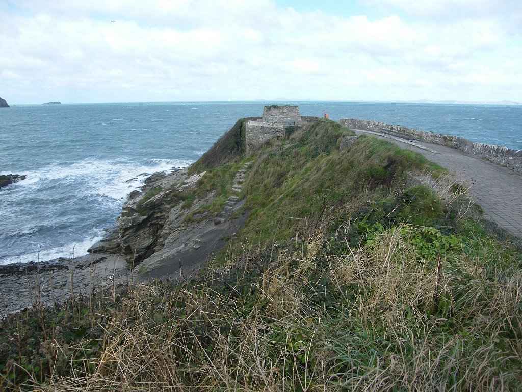
From
Little Haven the path is paved all the way up to what looks like a tiny ruined
fort. It is called “The Point”, but we
didn’t walk out to it because of the wind, it is a bit exposed. We followed the cliff path round past a woman
dressed in sandals and a kag who was lying on the grass smoking a
cigarette. (It takes all sorts….)
We came to a fearsome set of steps, but when we got to the top the path
levelled out. It was very much kinder
than the cliff paths further back. It
was mostly wide, and gently undulating with no big steps even when it crossed
the one and only cleft later on. Some of
it led through woods and some between hedges which gave us blessed relief from
that wretched wind. The geology looked
to be interesting — we found out later that the first stretch of today’s Walk
is all igneous rock. (I’m much more interested in igneous and
metamorphic rocks than sedimentary.)
The path came out into a quiet road for a few yards. At this point I had reckoned we had walked
3900 miles from Bognor along the coast.
So we found somewhere to put the camera and took our 3900 mile photo
using the delay timer. We passed a seat in the woods nicely sheltered from the wind which would
have been ideal for sitting on to eat our lunch — BUT (1) it was nowhere near
lunchtime, and (2) the seat was already occupied by a couple and their
dog. So we carried on and crunched crab
apples which were all over the path. I
saw a lizard! It was small and sandy
coloured, and ran quickly across the path in front of me. Colin didn’t see it because he was behind me,
and it had already escaped into the undergrowth by the time he came round.
We
were surprised at the large number of people we met who were as crazy as us,
out walking the coast path in such windy weather.
We found a grassy bank which was relatively sheltered where we could sit
and eat our sarnies. We both took off
our wet-weather gear while there as we found we were getting hot wearing
it. We had been mostly in sunshine, but
we could see rain pouring down behind Solva to the north. We hoped it wasn’t coming our way. We met a couple who told us, excitedly, that there were seals in the next
inlet. And so there were — four
white-coated baby seals hauled up on an inaccessible rocky beach way below us. We came to the only deep cleft on this Walk, to cross a stream. But the
path down was a gentle gradient, as was the path up the other side. There were no steps — it was a doddle! Further on we came to a rock balanced on another, and the top rock had a
hole right through the middle. No, it was
not natural erosion nor some ancient mythical stonework, it was a modern
sculpture! The rocks were bolted
together and we could see the marks of modern tools to make the hole. But what is it supposed to mean? I noticed that the rocks we were passing were now red, and so was the
sand in some places. “Looks like Old Red Sandstone!” says I —
and when I looked it up later I found that I was right. I was quite chuffed about that. Colin was looking at all the twisted rocks,
and I’m sure I spotted an unconformity amongst them. We sat on a bank to rest and eat our apples — I was getting tired though
Colin didn’t seem to be. Before we’d
finished it started to rain — so it was on with the wet-weather gear
again. But it didn’t last long, and was
finished before we hit St Brides Bay. There we scrambled across the beach, took off our wet-weather gear in
the toilet block, and sat at a picnic table to eat our chocolate. By then I was feeling quite fatigued and
wished we had terminated today’s Walk at St Brides. But then the next Walk would have been
longer, so you can’t win. I had to keep marching to keep me going, though it was an easy path. We passed St Brides Castle which seemed to be
some kind of posh hotel — at least, that is what we surmised when the bus we
were on called there this morning. (It picked up loads of posh women who were
wearing expensive rings and complaining loudly about the fare!)
We passed a drystone wall which had been
repaired with Old Red sandstone that had badly eroded. Geologically it was very interesting, and
pretty too. I was in route-march mode by now.
It seemed an awful long way to Black Cliff where we had to turn off on
to a path up to the road where our car was parked.
The sun was bright and low over the sea
making photography almost impossible. We
kept thinking we could see the signpost where the path went off but it always
turned out to be a fence post or somesuch.
Eventually we went through a gate which said, “Black Cliff”. Yes!
That’s it, the cliff really is jet black!
Trouble is, the path descends almost to sea
level before it starts going up to the junction — a cruel twist when I was so
tired. But it had been a very enjoyable
Walk!
That ended Walk no.382, we shall pick
up Walk no.383 next time At the junction of paths on Black Cliff, Marloes. It was twenty to six, so the Walk had taken
us six hours and forty minutes. A short walk uphill took us to the road
where our car was parked. We had tea and
chocolate biscuits before driving back to our caravan.
I must mention the children’s playground we came across in the village of Marloes this morning whilst waiting for
the bus. It is delightful, full of innovative ideas. There was a bamboo tunnel, a small bell
roundabout (how I remember the fun I used
to have on a big one of those as a child!) and a soup-plate swing. But what really caught my imagination was a
picnic table where the children could play draughts and snakes or
ladders. (I wanted to sit down and play myself, but we didn’t have time!) Lucky children who live in Marloes!


No comments:
Post a Comment