Ages: Colin was 75 years and 131 days. Rosemary was 72 years and 273 days.
Weather: Slate-grey sky. Windy at first but this died down. Light rain at the end.
Location: Marloes to West Dale.
Distance: 7½ miles.
Total
distance: 3913 miles.
Terrain: Cliff
top paths. Some steep undulations, but
many were level, wide and grassy.
Tide: Coming
in.
Rivers: None.
Ferries: None.
Piers: None.
Kissing gates: No.935 as we left Martins Haven.
Pubs: None.
‘Cadw’ properties: None.
Ferris wheels: None.
Diversions: None.
How
we got there and back: We were
caravanning near Whitesands
Beach. This morning we drove to Dale where we
managed to park for free near the church.
We walked into the village and had to ask where the bus stop was because
it wasn’t obvious. We caught a bus to
Marloes. After using the loos in the
village (couldn’t find the ones in Dale) we walked to the layby we had used yesterday,
then down the footpath to Black Cliff.
At
the end we turned off the coast path at West Dale and walked through a sugar
beet field to our car parked near the church.
After supping our tea and chocolate biscuits, we drove back to our
caravan at Whitesands in monsoon-like rain!
We started today’s Walk at Black Cliff, but we didn’t have to descend as
low as we did on the last Walk because the junction was halfway up the cliff
again. As we walked along we had good
views back towards Black Cliff and a lovely sandy beach. This is only accessible at low tide, and the
water was already too far in. We met quite a few people on this dull and breezy day, including one
couple who passed us backwards and forwards three times! He said, “We
can’t go on meeting like this!” I
replied, “Are you doing some sort of
zigzag route?” She said, No, we’ve staying in a cottage and we’re
looking for our bearings!” To which
Colin replied, “Well, I hope you find
them!”
It wasn’t a bad path. There were a
few more steep downhills and uphills than on the last Walk, but it wasn’t
nearly so difficult as the path round Solva way. Some sections were sheltered by a hedge. There were lovely views all along. We sat on a bank and ate our pies in a
not-very-sheltered position. We arrived in Martin’s Haven. The
only seat was already taken up by a couple, so we sat on a rock on the beach
and ate a sandwich. Colin thought he saw
a seal — and then we both saw it! The
last time we were here was with our local U3A Geology group back in 2011. We remembered we saw a seal then, and our
leaders were not too happy that most of the group stood watching the antics of
the seal rather than listen to them going on about rocks! We chatted about seals to the couple who had walked down from the
seat. Then we walked up to the toilet
block where we read a notice about boat trips to Skomer and Skokholm. When we added up boat fees and landing fees
we realised they would be very expensive trips.
We decided we weren’t that interested in birdwatching which is about the
only thing you can do when you get there. There was an inscribed stone in a wall cavity. A notice told us it was found in 1984 in the
foundation course of this Victorian wall.
The markings on the stone indicate it stems from the 7th to 9th
century, and about thirty such stones have been found in Pembrokeshire. It marks either a prayer station or a burial,
and is indicative of the high volume of pilgrim traffic between Pembrokeshire
and Ireland
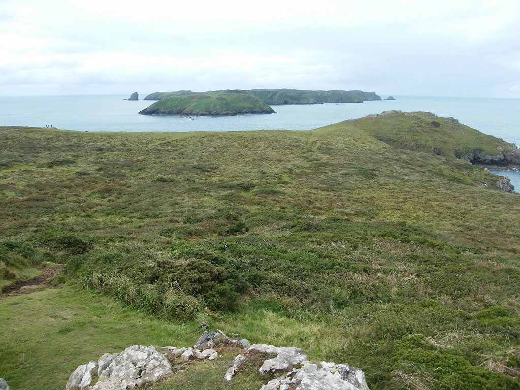
at that time. The official coast path misses out the end of the peninsula at Martin’s
Haven, but we decided to walk round it anyway if the weather was suitable
because we had the time. How glad we
were that we did! But first we had to
climb an almost vertical slope — I was pleased that I coped with this. Then we continued up gentler slopes to the
highest point where there was a coastguard lookout post.
We had magnificent views of the islands of
Skomer and Skokholm from there. We
decided they looked very bare — we had seen enough of them for free, neither of
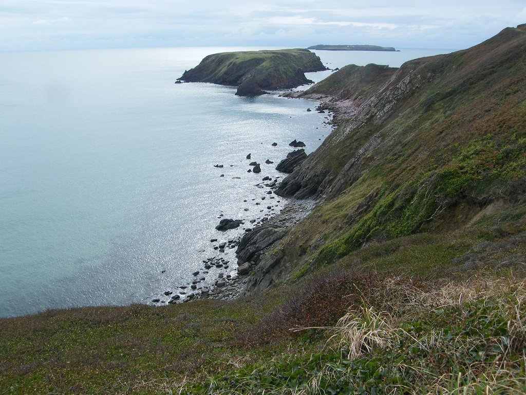
us particularly wanted to go there. We went down to the far side where it was fairly level, and there on the
beaches far below were a number of baby seals and their Mums! (We did
wonder if it wasn’t too early for grey seals to be born — we thought the
pupping season was November/December) It was great to watch them even though they didn’t exactly do very
much. We saw them on all the beaches
round to where we met up with the coast path again. We met lots of people to chat to, especially
a couple from Hong Kong where the woman was
jumping up and down with excitement! We
also saw lots of interesting rocks and caves — this really is a magnificent
stretch of coast! We sat on a grass bank and ate a second sandwich. Then we continued along the coast path
eastwards towards Marloes Sands. We met
two women who told us they were “WI walkers”. They were doing an 18 mile trek from Dale via St Ann’s Head and Martin’s
Haven to Little Haven. They then
planned, after dark, to walk round to Broad Haven on the beach when the tide
was out — about two of our Walks in one go and in the opposite direction. We don’t know if they made it, but since we
endured torrential rain from about 5pm onwards, I think perhaps not. Meanwhile, in fine weather we continued towards the corner opposite Gateholm Island where we were treated to
wonderful views! And there, just ahead,
was Marloes Sands. We had thought, when
studying the map, that perhaps we’d be able to walk a mile or so along this
sandy beach, but it was not so. The tide
was in and only a few disparate sections of shingly beach were exposed, each
cut off from the next by a rocky promontory.
Also, there was only one access point down the cliffs to the biggest bit
of beach so we would only have been able to scramble down there and come back
up the same way. We didn’t bother. But the views were superb! Twisted
rocks, vertical layers, rock arches, caves, etc — it was beautiful! We sat on a bank and ate our apples before
walking along the path at the top of the cliffs. As we approached the access point, we
descended steps almost to beach level then climbed steps up to clifftop level
again. The steps made my knees ache, but
nothing like the pain I used to experience before my knees were replaced. At the further end of Marloes sands we came to the remains of a wartime
airfield — parts of concrete runways are now all that is left. We sat on a rock to eat our chocolate. It started to rain, but it was only light at
first. We put the cameras away and
donned kags. Colin put on his
overtrousers but I didn’t bother (they are so hot to wear!) We went down another cleft, up again, and
finally down to the beach at West Dale. That ended Walk no.383, we shall pick
up Walk no.384 next time on the beach at West Dale Bay.
It was twenty past five, so the Walk had taken us six hours and fifty
minutes. We turned off the coast
path and walked inland through a sugar beet field to our car parked near the
church. After supping our tea and
chocolate biscuits, we drove back to our caravan at Whitesands in monsoon-like
rain!


No comments:
Post a Comment