Ages: Colin was 69 years and 116 days. Rosemary was 66 years and 258 days.
Weather: Warm.
“Fair-weather” cloud. PERFECT!
Location: Largs, via Ardrossan & Saltcoats, to
Stevenston.
Distance: 19 miles.
Total
distance: 2719 miles.
Terrain:
Beaches. Grassy paths. Tarmacked paths. Pavements.
Mostly flat.
Tide: Out, in, then
out again before we’d finished!
Rivers: No.333,
Gogo Water. No.334, Kel Burn. No.335, Stevenston Burn.
Ferries: None.
Piers: No.28 at Portencross — but it had great holes
in it!
Kissing
gates: No.224 where a closed road joined
a real road. No.225 leaving the nuclear
site. No.226 approaching
Portencross. No.227 got us on to the
beach near West Kilbride.
Pubs: None.
‘Historic Scotland’ properties: None.
Ferris wheels: None.
Diversions: None.
How we got there and
back: We towed our caravan from home to Ayr yesterday, having pre-booked the much nicer caravan
site in the town which we were unable to get in last time. This morning we drove to Stevenston and
parked the car in a picnic area by the beach.
We walked a few yards to the station where we caught a train to Largs. There we walked from the station to the pier
where we had finished the last Walk.
At the end we came to our
car a bit flustered, having got lost in the dunes! We had our tea, then drove to the river mouth
at Irvine to
find out if a footbridge across the River Garnock actually existed. It did, but a big chunk was missing from the
middle! That means we will have to make
a seven-mile detour inland on the next Walk, instead of a mere three miles
along the beach. With our hearts in our
boots, we returned to our caravan in Ayr.
We walked on the stone pier at Largs, and took a
photo of ourselves using the delayed timer because we have walked exactly 2700
miles along the coast from Bognor Regis.
(It has only taken us thirteen years to do this!) We were disappointed that the public
conveniences on Largs seafront were locked — it was a distinct inconvenience to
us, and probably to many of the other people milling about this September
morn.
A CalMac ferry came in from the Cumbrae Islands while we were faffing around, it
was full of schoolchildren. Our train
had also been full of them about half an hour earlier — teenage boys with their
shirts hanging out and teenage girls with tree-trunk legs wearing micro-skirts. Smart they were not, but I expect they were
‘cool’!
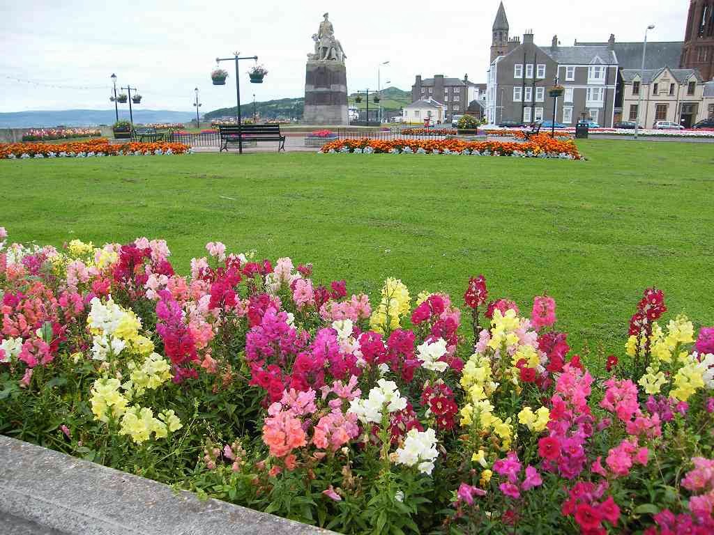
We crossed
the river on to a lovely esplanade backed by flower-filled gardens. They were quite spectacular, and lent a touch
of brightness to a rather grey morning.
But at least it wasn’t raining, and it did brighten up as the day
progressed. Our pies were still warm
from the shop near the station where they had been freshly cooked, so we sat on
the first seat we came to and devoured them — yum!


There were a couple of churches behind us, and we
could clearly see the bells in the open tower of one of them. I wonder how they cope with the weather in
this seafront location. We noticed a lot
of driftwood on the beach, and thought it must have floated in from the many
islands out to the west. In the ‘old’
days it would have been swept up in no time and put to good use by the local
populace. But here in the ‘throw-away’
21st century it lies ignored on the shore. There was lovely lighting across the water to
the little islands offshore, and towards Arran
beyond with its distinctive mountains.
We watched a heron fishing in the shallows.


We came to a structure that looked like a hangman’s
gibbet! But we rather think it was something
to do with hauling fishing boats in, though there weren’t any about at the
time. Then we came to a little rocky
promontory on which there stood a tall monument. There were also a few thick bushes about, at
last, behind which we both sought relief because every public convenience we
had passed so far was locked shut — shame on you, Largs Council! Feeling much more comfortable, we were able
to enjoy the continuation of the Walk.
Anyway, the tall tower was to commemorate the Battle of Largs, 1263, a
shoddy and indecisive affair when the Scots were trying to shake off the
sovereignty of the Norwegians. It was
finally settled over the negotiating table about three years later.
We could
clearly see the lines of rocks on the beach.
Further on we began to pass an exhibition of 20th century
anchors and floats displayed beside the path.
We were amused to note that the first ones were surrounded by neatly
clipped grass, but as we progressed the verges got increasingly weedy until the
exhibits were practically smothered by brambles, etc. However, there were some very pretty autumnal
bushes in between to compensate. The
wild flowers were lovely, though they were weeds really.
We passed a marina, then continued along a path
between the railway and the sea. I had
just commented on what a pleasant trail it was — when it came to an end! (I
should keep my big mouth shut!) We
were forced to go under the railway so that it was now between us and the
sea. There was a path for a little
while, but all too soon we were spat out on to the main road.
But there was a pavement, so we had no need
to don our yellow vests nor embark on car-dodging — must be grateful for small
mercies. We found we were following the
‘Ayrshire Coastal Path’, but way-marking was too infrequent and we kept losing
it.
At Fairlie
church we hooked back off the main road and walked through a housing
estate. We were now walking north again,
and the ‘Ayrshire Coastal Path’ signs told us to go straight on. So we ignored them and cut through to the
seafront. (I looked on the map later, and found the ‘Ayrshire Coastal Path’
continued northwards to a dead end — and stopped! What
was the use of that?) There was
no road nor esplanade where we were, so we went down on to the beach and
continued walking in our preferred direction — south
It was quite a nice beach really, sandy with a bit
of seaweed at the top and people walking their dogs. Looking south it seemed a bit
industrial. There was a long jetty and
domed structures that reminded me of the gasworks of my youth. But it was all mellowed by the wonderful
lighting across a calm sea, it was nearly beautiful, well almost!
We came to some rocks so we climbed up to a boat
pound — but the gates were locked. So we
went down the other side of the rocks and continued on the beach. The next steps led up to an alleyway, and then
to a residential road — that’s better! We were on the site of a boatyard where they
used to make yachts, from 1803 to 1939, three generations of the same family. Over nine-hundred yachts were built there
over that time, each with a golden dragon on the bow and a wheatsheaf near the
stern. There was a little sculpture on a
plinth to commemorate this family business.

At the end we were reluctant to turn up to the main
road again. So we went down a slipway
where we were pleasantly greeted by a local man blowing up an inflatable boat,
a zodiac type of thing. He told us it was possible to get round the next bit
of rock on the beach, there was a sort of path.
Yes, it was very ‘sort-of’, but we coped. It did improve, and we found a seat to sit
on. Colin adjusted his insole because he
had a painful heel. We each ate a
clementine which was nice and sweet.
On
round the next corner to a picnic area, where we sat down again to eat a
sandwich each. It was far too early for
lunch, but we both felt hungry so we decided to ‘graze’ all day. We knew today’s Walk was going to be a long
one and we should have brought extra food — but we hadn’t.
After that we had to rejoin the main road, but there
was a pavement so it wasn’t too bad. We
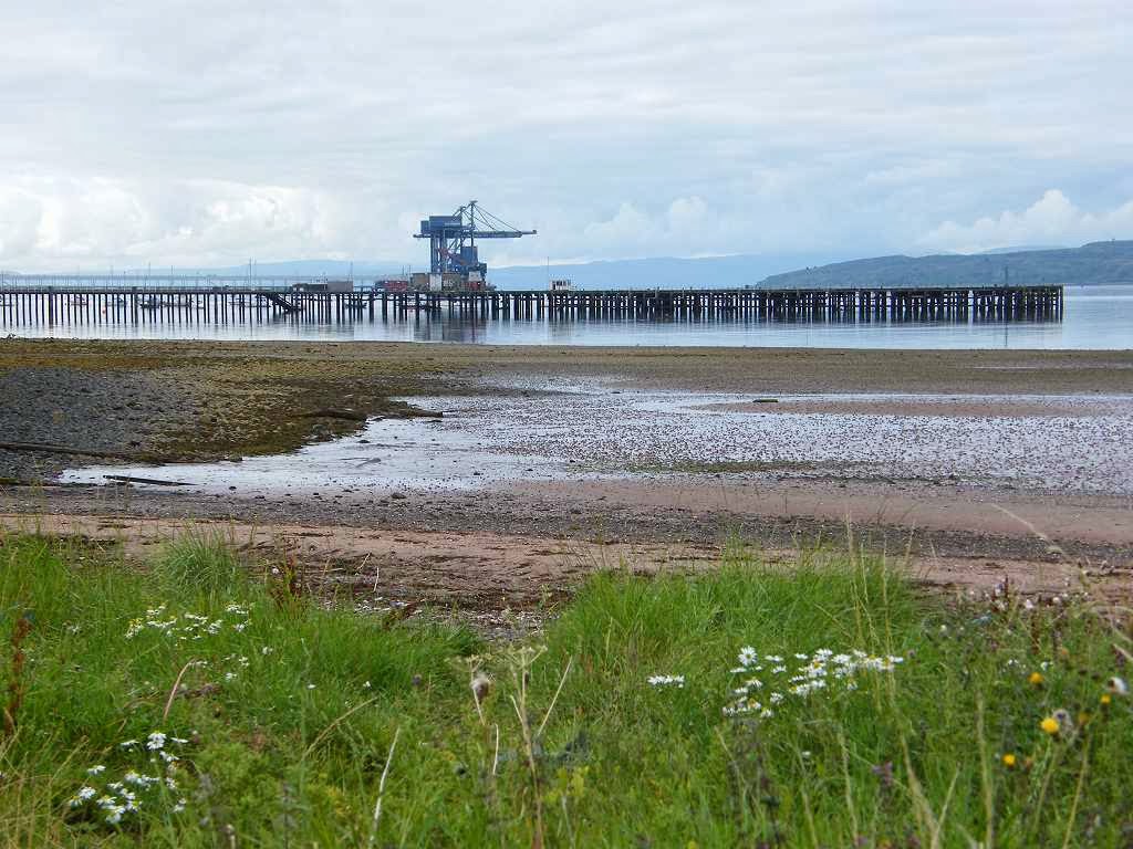
came to what was marked on our map as an ‘ore terminal’. A pretty footpath over a stone bridge led off
round it, but we didn’t know if we could get through to the other side because
this path was not marked on our newly bought OS map. There was no sign of an ‘Ayrshire Coastal
Path’ notice, neither directing us straight on nor round the ‘ore
terminal’. There was just a ‘Pedestrians
only’ notice and a Marie Curie ‘Field of Hope’.
We decided to try it. It was a
good path leading round in a curve so we couldn’t see what was coming up. It even had seats at intervals, so it was
meant to be used.

Then we met a couple
coming towards us, so we asked them if it was a dead end — yes, it was! They were very pleasant and informative —
local knowledge you see! They described
in detail the way we should go, and were very interested in our project. I hope you are still reading this blog,
lovely people! We went a little further
to get a view of the jetty, then we retraced our steps.


We yomped along the main road, and we were pleased
that the pavement we were on veered away from the road through a tree tunnel on
two occasions. Just before a roundabout,
a path labelled ‘Ayrshire Coastal Path’ led off through the trees to the
right. This took us to a ‘Road Closed’
notice which the couple back at the ore terminal had spoken about. We ignored it, as instructed, and carried
on. We came to a cycle path leading off
to the left and signposted ‘Seamill’ which was a place we knew we wanted to get
to eventually. But was there a route
closer to the sea? We asked a passing
dogwalker if we could get round the nuclear power station which, according to
our map, was where the road was leading.
Although he lived locally, he didn’t know. (So much for local knowledge!) However he was chatty, and tried to be
helpful. He told us about the ‘Hole in
the Ground’ which was the promontory we could see to our left as we faced the
muddy bay. He said they used to build
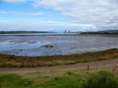
oil platforms there in the 70s and 80s, but the site was now derelict. He told us it was possible to walk all round
it, but we decided not to on the grounds that it was a dead end and we hadn’t
got time.

The closed road joined up with a real road, and
there we found an ‘ Ayrshire Coastal Path’ sign directing us on towards the
nuclear power station. It was a good
road — we walked on the pavement next to it admiring the harebells in the
grass. Colin stopped to take some
painkillers because his heel was still giving him grief.
We followed the road all round to the nuclear power
station — it even took us between some of the buildings and past a bus-shelter
affair which was a dedicated smoking area.
We kept passing people wearing high-vis coats and hard hats, we really
felt as if we shouldn’t have been there.
But it was as if we were invisible — nobody bade us “Nay!” even though I
was taking photographs in all directions.
There were all sorts of notices about this being a licensed nuclear
site, no access to the beach because of ‘sharp objects’ and no entry to the
jetty, but nowhere did it say we couldn’t continue. At last we came to the far end, and there was
an ‘Ayrshire Coastal Path’ notice pointing onwards. So we had
been legal all along, it was nice to know in retrospect.
We sat on a rock to eat a second sarnie — we were
trying to pan our food out to last the Walk.
We continued along a good flat path on what I concluded was a raised
beach — for there were cliffs over to the left of us well away from the sea.
It was very pleasant, and we met several
groups of people meandering towards us and continuing as far as the entrance to
the nuclear power station where they mostly turned round.
We had wonderful views out towards Arran, and also enjoyed the flowers and butterflies down
by our feet. The weather had brightened
up, and we had a lot of blue sky. This
really was a pleasant part of the Walk.
We kept seeing rough patches in the sea, as if tiny
fish were being pushed up in a ‘bait-ball’.
But we couldn’t see any predator around, and the water was very shallow
where this happened anyway. Each patch
lasted just a few seconds, then it would die down…….and rise up a bit further
on.
We watched fascinated for some time,
but we could only see the splashes — it was always so quick. We weren’t sure if it was fish causing it, or
something else. It was almost impossible
to photograph because we never knew where it was next going to rise up and
there wasn’t time to position the camera and press the shutter before it was
all over. So I spent a long time taking
videos — mostly of a calm sea! We got
into conversation with a man who hailed from Worcester and walked along with him for a
bit. He had no idea what was causing the
water disturbance either.


We came to Portencross where there was a small
wooden pier with several big holes in it!
It wasn’t cordoned off, so we skirted the holes to speak to the
fishermen at the end. They hailed from Sheffield, and reckoned that the water disturbance was
caused by sand eels being preyed on from underneath. But the
water is too shallow for that! I
stood for a while trying to catch the phenomenon on video while Colin managed
to get himself caught up in one of the fisherman’s lines — the fault of both of
them really, Colin was too close and the fisherman too careless.
No harm done, and we carried on past a tiny harbour towards
the small castle which closed for the season yesterday! It is a 14th century structure,
built by the Boyd family to defend sea routes and access to the islands across
the Firth of Clyde. There was an elderly
man standing outside his cottage nearby.
He told us, “I had to come out to see if it was true! Have you seen the herring fry? I haven’t seen them do that in sixty
years!” He was very animated and
excited as he explained that the patches of disturbed water we had noticed were
newly hatched herrings swimming in shoals.
“This means the fish stocks are rising at last! They are very small now, but give ‘em a few
weeks and they’ll be as big as sardines!”
He then went on to tell us stories of his fishing exploits in these
parts when he was a boy during the War.
His tales were very interesting, I only wish we’d had more time to stop
and listen to him.
We crossed a picnic site and went down a bumpy path
to the beach. We could still see Ailsa
Craig, that volcanic plug in the middle of the sea, but it was too far away to
photograph. We had miles of
beach-walking ahead of us, which was very pleasant.
Sometimes it was sandy, but even when it was
stony it wasn’t too bad for walking. I
looked at the variety of stones under my feet, and wondered how many different
rock types they represented. They
certainly were very pretty — I’ve always liked round stones, ever since I was a
tiny child. I remember I used to collect
them and put them in a purse. We had
shells crunching under our feet for one stretch of the beach, we couldn’t help
but tread on them.
West Kilbride
looked a nice place to live with the houses spreading uphill from the
beach. Colin’s heel was still troubling
him, and I had a leg-ache which I strongly suspected was sciatica. So we stopped and both took painkillers.
We saw a birdwatcher out on the rocks with
his telescope, and the birds he was watching sitting on another set of
rocks.
We crossed a stream using a
footbridge, then walked along a pleasant grassy path between houses and the
sea.
We sat on a rock for an apple break, looking at the
view and the many birds on rocks in the shallows.
One of the rocks we were looking at had a
message for us — it said, “Take home litter please!” Colin had been walking quite slowly, which
was unusual for him, and he was exceptionally quiet. I think his cracked heel was causing him more
grief than he was prepared to admit.
We
walked round some fields on a small promontory, it was quite a bumpy path. A pub was marked on the map at the end of the
fields, and we were looking forward to a rest and some refreshment. But when we got there all we could see was a
building site surrounded by security fencing — what a disappointment! So we went back on to the beach for a few
more miles. There was a busy main road
along the top so we were much better off down below even when the sand gave way
to rocks.
As we approached Ardrossan the beach got too rocky
to walk safely, and we decided it would have to be the main road from now
on. When we got up there we found there
was a cyclepath along the beach side of the road, so it wasn’t so bad after
all.
We came across a very old milestone
which was so eroded we could barely read the writing on it. But at least it was still there, tarmacked
into the edge of the modern cyclepath — most of the country’s ancient
milestones were removed during the Second World War to confuse the enemy should
Hitler invade.
Colin admitted he’d had enough. So when we entered Ardrossan we missed out a
new housing estate, which wasn’t marked on the map anyhow. And we missed out the road to the ferry
terminal on the grounds that it was a dead end.
We decided to make up a new rule that if we were tired and fed up
towards the end of a long Walk we could make up excuses to take a
shortcut. (Hadn’t we been doing that
anyway?)
We sat on a bench overlooking South Beach
and ate our chocolate. Not far to go
now! During our Walk the tide had gone
out, come in, and was on its way out again.
So we decided to cut straight across the crescent-shaped beach to
Saltcoats — and for once we didn’t come unstuck. In fact it was gorgeous in the evening light,
especially when sunbeams pierced the clouds in the distance.
Windmills inland told us how breezy this place can be. Wouldn't do for me, I hate wind!
We passed tidal pools as we walked round the
concrete spur in Saltcoats. But
this headland had been built on Carboniferous rocks (deposited 310 million
years ago, the coal-bearing strata). A
notice board told us all about the geology. It told us that there are about
thirty fossil tree stumps in Saltcoats, but by now we were really too tired to
go and look for them. (We have seen an
excellent fossil forest near Lulworth Cove in Dorset
some time back, and told ourselves “That’ll do!”)
We were also told that there were volcanic
intrusions of rock on the beach forming sills.
But all we wanted to do by this stage was to get back to the car parked
a couple of miles further on at Stevenston.
We did stop for a couple of minutes to look at the
‘Talking Wall’, a new kind of community sculpture. Colin wanted to get on, but I tarried a
little to read some of the thoughts on the seaside. “One time my granda took me out on his boat
and I got to sail for a while” – Andrew,
aged 11. “Going to the beach is much better
with a dog” – Megan, aged 11. “I was eating chips with my nana and Irene in
the car park and we were swarmed by seagulls attacking the car” – Brandon, aged 11. “Summer in Saltcoats – diving for pocket
money thrown in by holiday makers at full tide when a thrupenny bit was worth
something back in 1942” – Ron. “I remember wondering where the horizon led
to” – Lauren, aged 14. There were many more, but I was tired too so
we carried on.
We didn’t go along the harbour wall because we were
really tired and it was a dead end.
There were lots of young people about being very loud, and we couldn’t
understand their Scottish accents — we were really too weary for all of
this.
We emerged on the East shore, but
it was not a nice beach at all. It was
rocky and muddy, and besides it was still covered in shallow water. This didn’t seem to be a very savoury part of
Saltcoats, there was something about the area we couldn’t quite explain. We felt a bit vulnerable, so we marched on
quickly and with purpose to get away from it as fast as we could.
We followed a cycle trail until it veered away from
the beach. Then we entered the sand
dunes, looking for the footbridge across the river which we knew was
there. We thought we were on the
Ayrshire Coastal Path, but after the initial sign there was no other and we got
lost.
Climbing up and down dunes was no
fun in our state of weariness, we both got extremely cross. When down in a hollow it is so easy to get
disorientated, and up on a mound we simply couldn’t see the footbridge at
all. We just didn’t need this at the end
of such a long Walk!
Eventually we found
it — if we’d stayed on the beach, which was dry sand from where the cycle trail
veered away from it, we would have come to the bridge without difficulty. Hindsight, and all that….. The path the other side of the river led us
straight to our car — relief!
That ended Walk no.279, we shall pick up Walk no.280
next time in the beach picnic area in Stevenston. It was ten past seven, so the Walk had taken
us ten hours and forty minutes. We had
our tea and biscuits before driving back to our caravan in Ayr. On the way we diverted to the river mouth at Irvine to find out if a
footbridge across the River Garnock actually existed. It’s a good thing we checked up on this
despite our fatigue because this vital bridge did exist but had a big chunk
missing from its middle!
We asked a
local man if he knew why it was like that because it was obvious that the
middle section had been deliberately removed.
He said he didn’t really know, but thought it was something to do with
the industrial units on the other side going bust. What it means for us is that we will have to
make a seven-mile detour inland on the next Walk, instead of walking a mere
three miles along the beach. Four
extra miles! With our hearts in
our boots, we returned to our caravan in Ayr.


No comments:
Post a Comment