Weather: Very grey, but the rain just about held
off. Brightened a little later. Mild.
Location: Stevenston, via Irvine, Troon & Prestwick, to Ayr.
Distance: 22 miles.
Total distance: 2741 miles.
Terrain: Tarmac at first, then long stretches of sandy beach (LUVLEY!). Flat.
Tide: Out, then came right in.
Rivers: No.336, River Garnock. No.337, tributary of same. No.338, Pow Burn.
Ferries: None.
Piers: None.
Kissing gates: No.228 in, and no.229 out of “Holiday Park” (ie the caravan site we stayed at last time and didn’t think much of) at the end of Prestwick Airport runway.
Pubs: “The Harbour Bar” in Troon, where Colin drank Kelburn beers — “Misty Law” & “Tartan Army”. I had a shandy. The pub was a terrible dive, and we couldn’t get out of there quick enough!
‘Historic Scotland’ properties: No.29. Dundonald Castle which we visited on another day.
Ferris wheels: None.
Diversions: No.60 — we had to walk four miles extra using mostly a cycleway because a footbridge over the River Garnock had the middle chunk missing.
How we got there and back: We were staying in our caravan on a site in Ayr. This morning we walked to Ayr station and caught trains to Stevenston. The persistent rain stopped just as we alighted from the train.
At the end we walked along
the river from the first bridge where we finished our Walk, to our
caravan. We didn’t use the car at
all!
As soon as we alighted from the train at Stevenston station we ran to the shelter and hurriedly put on our wet-weather gear. Then the rain stopped — typical! We walked down to the car park where we finished the last Walk, and from there we cut across the dunes to the beach.

 The tide was out, and we could clearly see the
little river (that we had crossed two days ago on the hidden bridge) meandering
its way across the beach. We took a
short cut towards the Point by walking across the sands — we love walking across sandy beaches! Some of the rocks looked like pumice because
they were full of gas holes, but they were too heavy. Obviously a volcanic rock though.
The tide was out, and we could clearly see the
little river (that we had crossed two days ago on the hidden bridge) meandering
its way across the beach. We took a
short cut towards the Point by walking across the sands — we love walking across sandy beaches! Some of the rocks looked like pumice because
they were full of gas holes, but they were too heavy. Obviously a volcanic rock though.
 Near the Point the sand turned into rocks and the
dunes turned into cliffs, so we scrabbled up a lumpy grass bank to the car park
road above. We didn’t go down to the end
of the Point because it was a dead end, and we didn’t make for the beach beyond
it because three miles further on the footbridge across the River Garnock had a
huge chunk missing from its middle. We had
to make a seven mile detour inland to cross this river, lengthening today’s
Walk to 22 miles! So we thought we’d
better get on with it.
Near the Point the sand turned into rocks and the
dunes turned into cliffs, so we scrabbled up a lumpy grass bank to the car park
road above. We didn’t go down to the end
of the Point because it was a dead end, and we didn’t make for the beach beyond
it because three miles further on the footbridge across the River Garnock had a
huge chunk missing from its middle. We had
to make a seven mile detour inland to cross this river, lengthening today’s
Walk to 22 miles! So we thought we’d
better get on with it.
 We turned round and walked across a big grassy
recreation area which was lovely except for the plethora of doggy-poo we had to
avoid. Children playing on there would
have been covered in the stuff — such a pity that a large play area like that
should be ruined by a few lazy and selfish dog-owners. We made for the end of a row of houses.
We turned round and walked across a big grassy
recreation area which was lovely except for the plethora of doggy-poo we had to
avoid. Children playing on there would
have been covered in the stuff — such a pity that a large play area like that
should be ruined by a few lazy and selfish dog-owners. We made for the end of a row of houses.
 We had about a mile to walk alongside roads, mostly
with pavements, before turning off on a cyclepath. As we crossed over the first railway,
graffiti on the bridge read, “Welcome to Ardeer”. Now Ardeer is the huge derelict area we were
walking round — it looks a bit like barracks on the map. It seemed more rural than we had been led to
believe, it must have been abandoned a long time ago. Colin kept going on about ‘short-cuts’
(doesn’t he ever learn?) but he shut
up when he saw how swampy it was. Even a
disused racecourse is called ‘Bogside’!
We had about a mile to walk alongside roads, mostly
with pavements, before turning off on a cyclepath. As we crossed over the first railway,
graffiti on the bridge read, “Welcome to Ardeer”. Now Ardeer is the huge derelict area we were
walking round — it looks a bit like barracks on the map. It seemed more rural than we had been led to
believe, it must have been abandoned a long time ago. Colin kept going on about ‘short-cuts’
(doesn’t he ever learn?) but he shut
up when he saw how swampy it was. Even a
disused racecourse is called ‘Bogside’!

 We crossed railways and a main road several times
using bridges or tunnels. We saw
starlings gathering on wires and a lot of fly-tipping — there was no shortage
of three-piece-suites!
We crossed railways and a main road several times
using bridges or tunnels. We saw
starlings gathering on wires and a lot of fly-tipping — there was no shortage
of three-piece-suites!

 We came to the river at last next to some weirs, but
crossing it there would have taken us inland in completely the wrong
direction. We had to follow the map very
carefully. We kept on our side of the
water, winding round in a half-circle.
Then under the dual carriageway after which we crossed the river on a
minor road. It was a good tarmacked
cyclepath all the way, now all we had to do was to get back to the seashore.
We came to the river at last next to some weirs, but
crossing it there would have taken us inland in completely the wrong
direction. We had to follow the map very
carefully. We kept on our side of the
water, winding round in a half-circle.
Then under the dual carriageway after which we crossed the river on a
minor road. It was a good tarmacked
cyclepath all the way, now all we had to do was to get back to the seashore.

We continued southwards, and after about a mile we found we were alongside a tributary of the River Garnock. This also needed crossing, but not yet. Colin found a baby toad in the grass verge.

 We were in a much more built-up area by now. Over the tall weeds we could see a half-built
apartment building that looked as if it had been abandoned to the elements
before the final waterproof layer could be added. Further on we could just see the top of a
roofless church.
We were in a much more built-up area by now. Over the tall weeds we could see a half-built
apartment building that looked as if it had been abandoned to the elements
before the final waterproof layer could be added. Further on we could just see the top of a
roofless church.
 It struck us that were not in a very salubrious
area. We came into the edge of a town,
went under a dual-carriageway and crossed the tributary on a small bridge — but
it was different in reality from the map and we found it quite confusing. At last we were fully over the waterway which
had caused this long diversion. We came
to a roundabout which we recognised from our recce two days ago when we came to
find out about the footbridge with the chunk missing.
It struck us that were not in a very salubrious
area. We came into the edge of a town,
went under a dual-carriageway and crossed the tributary on a small bridge — but
it was different in reality from the map and we found it quite confusing. At last we were fully over the waterway which
had caused this long diversion. We came
to a roundabout which we recognised from our recce two days ago when we came to
find out about the footbridge with the chunk missing.
 Here we found an ‘Ayrshire Coastal Path’
notice, the first we had come across today and we had already walked six
miles. But even this was confusing in
its direction. So we followed the road
until we got to the riverside.
Here we found an ‘Ayrshire Coastal Path’
notice, the first we had come across today and we had already walked six
miles. But even this was confusing in
its direction. So we followed the road
until we got to the riverside.

 Colin saw a chip shop! I left him to it, and went on past a small shipyard
and a statue of a man with a horse until I came to a seat near the broken
footbridge. I wanted to know that I had
completed the diversion before I sat down — our first rest in seven miles. Colin soon caught me up having eaten most of
the chips he had just bought. He felt a
lot better then! Earlier he had taken
codeine for his heel trouble, and he didn’t mention it for the rest of the
day. He was much brighter after eating
his chips, and we both ate our pies.
Colin saw a chip shop! I left him to it, and went on past a small shipyard
and a statue of a man with a horse until I came to a seat near the broken
footbridge. I wanted to know that I had
completed the diversion before I sat down — our first rest in seven miles. Colin soon caught me up having eaten most of
the chips he had just bought. He felt a
lot better then! Earlier he had taken
codeine for his heel trouble, and he didn’t mention it for the rest of the
day. He was much brighter after eating
his chips, and we both ate our pies.

 We idly watched Mums with toddlers feeding the gulls
with white bread. (Note: Never
feed seagulls because they are a pest! And never feed wild birds white bread
because it is bad for their digestion and can end up killing them! Won’t these messages ever get through?) The Mums seemed more enthusiastic than the
youngsters, who toddled off bored with the proceedings. Anyway, enough of this idle chatter, we still
have a lot of walking to do.
We idly watched Mums with toddlers feeding the gulls
with white bread. (Note: Never
feed seagulls because they are a pest! And never feed wild birds white bread
because it is bad for their digestion and can end up killing them! Won’t these messages ever get through?) The Mums seemed more enthusiastic than the
youngsters, who toddled off bored with the proceedings. Anyway, enough of this idle chatter, we still
have a lot of walking to do.
 We walked past the broken footbridge. I discovered the story behind it on the
internet. A dynamite factory was
established in the dunes of Ardeer in 1870.
At the time it was the largest explosives factory in the world. This eventually became a part of ICI. I couldn’t find out when it closed, but at
the end of the 20th century the Big Idea was born. A huge building, costing £14million was
constructed to house the ‘Museum
of Scottish Invention’. It was accessed by a bridge which was
constructed in an innovative roll-back design.
Instead of swinging horizontally or vertically, the museum end could slide
back over itself, creating a central opening through which tall vessels could
pass. The museum was never financially
viable, and closed three years later with huge debts. I suppose the bridge has been in the
roll-back position ever since.
Apparently most of the exhibits are still inside the building and are
for sale, but nobody wants to buy — I wonder if they have tried e-Bay! There are grandiose plans to turn the whole
place into a golfing complex, but so far no one has stumped up the money.
We walked past the broken footbridge. I discovered the story behind it on the
internet. A dynamite factory was
established in the dunes of Ardeer in 1870.
At the time it was the largest explosives factory in the world. This eventually became a part of ICI. I couldn’t find out when it closed, but at
the end of the 20th century the Big Idea was born. A huge building, costing £14million was
constructed to house the ‘Museum
of Scottish Invention’. It was accessed by a bridge which was
constructed in an innovative roll-back design.
Instead of swinging horizontally or vertically, the museum end could slide
back over itself, creating a central opening through which tall vessels could
pass. The museum was never financially
viable, and closed three years later with huge debts. I suppose the bridge has been in the
roll-back position ever since.
Apparently most of the exhibits are still inside the building and are
for sale, but nobody wants to buy — I wonder if they have tried e-Bay! There are grandiose plans to turn the whole
place into a golfing complex, but so far no one has stumped up the money.

 We walked to the end, the mouth of the river, and
once more we were on the seashore! There
was an unusual sculpture of a fisherman sailing through a huge wave. A bit of a prom to walk, and then we were on
the sands.
We walked to the end, the mouth of the river, and
once more we were on the seashore! There
was an unusual sculpture of a fisherman sailing through a huge wave. A bit of a prom to walk, and then we were on
the sands.
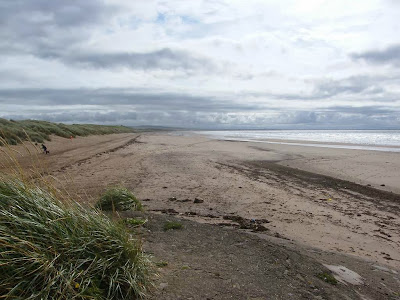 Five miles of sandy beach to walk — lovely! We outwalked everyone — including a
man with a dog and two girls on horses, they all turned back eventually.
Five miles of sandy beach to walk — lovely! We outwalked everyone — including a
man with a dog and two girls on horses, they all turned back eventually.
 There were plenty of stranded jellyfish, some
of them were huge!
There were plenty of stranded jellyfish, some
of them were huge!

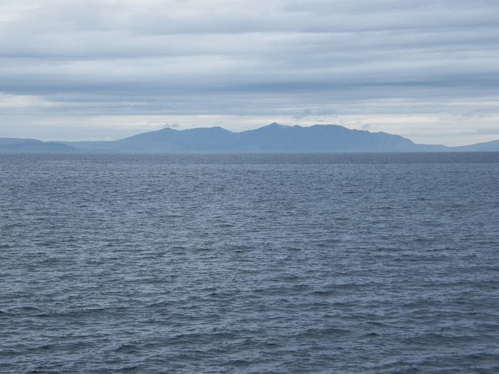
 We could see the
volcanic plug of Ailsa Craig out to sea.
If you have £2.5million to spare you can have it — for it is on the
market for that amount. You will have to
share this tiny island with 36,000 breeding pairs of gannets, you will have no water, electricity, gas, sewage
or telephone connections — but you can expect to make a profit of £27,000 a
year from the quarrying of curling stones, the only place in the world where
these stones are cut. We also had views
of Arran all along.
We could see the
volcanic plug of Ailsa Craig out to sea.
If you have £2.5million to spare you can have it — for it is on the
market for that amount. You will have to
share this tiny island with 36,000 breeding pairs of gannets, you will have no water, electricity, gas, sewage
or telephone connections — but you can expect to make a profit of £27,000 a
year from the quarrying of curling stones, the only place in the world where
these stones are cut. We also had views
of Arran all along.
 We saw an odd building on the dunes behind the
beach, but didn’t have time to go up and find out what it was. From our angle it looked like a giant rabbit
or caterpillar! We also puzzled about a
post we could see out to sea — and came to the conclusion that it must be a
marker buoy on a rock lurking just beneath the surface of the water.
We saw an odd building on the dunes behind the
beach, but didn’t have time to go up and find out what it was. From our angle it looked like a giant rabbit
or caterpillar! We also puzzled about a
post we could see out to sea — and came to the conclusion that it must be a
marker buoy on a rock lurking just beneath the surface of the water.
As soon as we alighted from the train at Stevenston station we ran to the shelter and hurriedly put on our wet-weather gear. Then the rain stopped — typical! We walked down to the car park where we finished the last Walk, and from there we cut across the dunes to the beach.


We continued southwards, and after about a mile we found we were alongside a tributary of the River Garnock. This also needed crossing, but not yet. Colin found a baby toad in the grass verge.


We reached Barassie where the beach got too rocky to walk on comfortably. We went up to a cycleway and found a bench to sit on in order to eat our sarnies. Trouble was, we were in a popular dog-walking area, and one rascally mutt almost managed to get away with Colin’s sandwiches!


We passed the site entrance, and crossed the river on a track over a low wooden bridge. There was a poem on the gate leading back to the beach. It read:
The Ayrshire Coastal Path
Be ye Man – or Bairn – or Wumman,
Be ye gaun – or be ye comin,
For Scotland’s
Pride – no Scotland’s
shame,
Gether yer litter – an tak it Hame!
(We actually saw this poem
in several other places along the way.)
Now it’s all very well writing poems, but there was a distinct lack of
Ayrshire Coastal Path signs and a confusing path network leading over the
dunes. We had to ask some ladies walking
towards us which way we should go to get back to the beach — we’ve got lost in
sand dunes before, and didn’t want to repeat the experience.


That ended Walk no.280, we shall pick up Walk no.281 next time at the first bridging point on the River Ayr. It was twenty-five to seven, so the Walk had taken us ten hours and twenty minutes. We walked inland along the river until we reached our caravan site. We were proud of the fact that we hadn’t used our car at all today!

No comments:
Post a Comment