Weather: A cold but sunny start. Light cloud later. It did get warmer as the day progressed, but
it was still cold in the breeze when we were up high.
Location: Stranraer to Portpatrick.
Distance: 13 miles.
Total distance: 2813 miles.
Terrain: Concrete. Stony beach. Quiet roads. A cliff path. Undulating, especially the cliff path.
Tide: In, going out.
Rivers: None.
Ferries: None.
Piers: None.
Kissing gates: Nos.260 to 262, all on the cliff path just beyond the lighthouse.
Pubs: None.
‘Historic Scotland’ properties: None.
Ferris wheels: None.
Diversions: No.62 round renovations at Stranraer.
How we got there and back: We were staying in our caravan on a site at New England Bay on the South Rhins. This morning we drove to Portpatrick and parked by the harbour. Then we caught a bus from the village to Stranraer.
At the end we were at the car. We drove back to our caravan at New England Bay where we had our tea and biscuits.
 We were exactly at our 2800 mile point in Stranraer,
so we set up the camera to take a photo of both of us on the timer. Then a lady came along with her dog, so we
asked her to take a picture of us. Hers
came out better, so we ditched the other one.
We got chatting to this lady, and told her about our Trek and the
significance of the photo she had just taken.
She was a walker too, and told us she had once done the Three-Fells Walk
“which nearly killed me!”
We were exactly at our 2800 mile point in Stranraer,
so we set up the camera to take a photo of both of us on the timer. Then a lady came along with her dog, so we
asked her to take a picture of us. Hers
came out better, so we ditched the other one.
We got chatting to this lady, and told her about our Trek and the
significance of the photo she had just taken.
She was a walker too, and told us she had once done the Three-Fells Walk
“which nearly killed me!”
 We walked along to the pier where we got
confused. It seemed to be a large
building site, but there was a doorway in the fencing with the word
“Pedestrians” over it in big red letters.
It was only after we walked through it that we realised that didn’t mean
us! It meant pedestrian workers on the
building site, so we retreated and looked for a safe way round it. The pier was closed due to the fact it was
pretty derelict.
We walked along to the pier where we got
confused. It seemed to be a large
building site, but there was a doorway in the fencing with the word
“Pedestrians” over it in big red letters.
It was only after we walked through it that we realised that didn’t mean
us! It meant pedestrian workers on the
building site, so we retreated and looked for a safe way round it. The pier was closed due to the fact it was
pretty derelict.

 In fact the whole of the waterfront was behind
security fences, undergoing a major makeover.
We had to pick our way along the outside of it, and in places wondered
whether we would be able to get through.
We had to divert right on to the beach at one point, and it wasn’t easy
walking being as it was all stony.
In fact the whole of the waterfront was behind
security fences, undergoing a major makeover.
We had to pick our way along the outside of it, and in places wondered
whether we would be able to get through.
We had to divert right on to the beach at one point, and it wasn’t easy
walking being as it was all stony.

 But looking to the right we had wonderful views of
the North Rhins, stretching out almost seeming
to meet the Ayrshire coast where we had been walking two days ago. We could just see Ailsa Craig peeping out
behind the hill we had walked over in the sleet when feeling so cold. We were not cold today, it was a beautiful
sunny day with not a breath of wind — the sea was like a mill pond. I got Colin to throw a pebble in the water
just as I took a photo, and was very pleased with the resulting image.
But looking to the right we had wonderful views of
the North Rhins, stretching out almost seeming
to meet the Ayrshire coast where we had been walking two days ago. We could just see Ailsa Craig peeping out
behind the hill we had walked over in the sleet when feeling so cold. We were not cold today, it was a beautiful
sunny day with not a breath of wind — the sea was like a mill pond. I got Colin to throw a pebble in the water
just as I took a photo, and was very pleased with the resulting image.

 We passed a mural that was of a stormy sea with fish
— I really liked this piece of Art. We
passed a building where we were told the flat roof was fitted with an
anti-climbing rail incorporating revolving cacti (!) And we passed a wall plaque which told us a
creamery was once on this site.
We passed a mural that was of a stormy sea with fish
— I really liked this piece of Art. We
passed a building where we were told the flat roof was fitted with an
anti-climbing rail incorporating revolving cacti (!) And we passed a wall plaque which told us a
creamery was once on this site.
 We passed all the works, then we were able to walk
along the prom until it came to an end.
The surface wasn’t very good on this latter bit, perhaps they are going
to extend the works and improve it in time.
We passed all the works, then we were able to walk
along the prom until it came to an end.
The surface wasn’t very good on this latter bit, perhaps they are going
to extend the works and improve it in time.
There was still a warning notice about the waves from ferries up to 30 minutes after the ferry had gone past. We looked across the bay — the ferries seemed a long way away.
 I put my camera on maximum zoom and took
pictures of both a P&O ferry and a StenaLine ferry at their respective berths.
I put my camera on maximum zoom and took
pictures of both a P&O ferry and a StenaLine ferry at their respective berths.
 When the prom ran out we walked about fifty yards
along the stony beach until we came to a path leading up into bluebell
woods. It seemed to run parallel to the
shore and was much easier than the beach, so we followed it for about a hundred
yards.
When the prom ran out we walked about fifty yards
along the stony beach until we came to a path leading up into bluebell
woods. It seemed to run parallel to the
shore and was much easier than the beach, so we followed it for about a hundred
yards.
 It ended at a private house! By then we were up on a bit of a cliff about
twelve foot high, so we had to return to where we’d entered the woods. We weren’t best pleased.
It ended at a private house! By then we were up on a bit of a cliff about
twelve foot high, so we had to return to where we’d entered the woods. We weren’t best pleased.
 We continued along the beach. It was stony, but not too bad to walk. Colin delighted in looking for fossils in the
beach stones. At the inevitable golf
course we went up and walked along the edge of the greens. It made a bit of relief from the stones. But then we came to fields with barbed wire
fences, so we had to return to the beach.
We sat on a bank to eat our pasties — well Colin did, I had a slice of
quiche.
We continued along the beach. It was stony, but not too bad to walk. Colin delighted in looking for fossils in the
beach stones. At the inevitable golf
course we went up and walked along the edge of the greens. It made a bit of relief from the stones. But then we came to fields with barbed wire
fences, so we had to return to the beach.
We sat on a bank to eat our pasties — well Colin did, I had a slice of
quiche.
Before we reached the river at Soleburn Bridge, we went up to the road. We’d had enough. The tide was in, the narrow beach was stony and there obviously was no path. We abandoned our original plan of walking along the beach to Kirkholme and back along the shore — this decision saved us seven miles! The rest of North Rhins is dead ends, very few of which actually lead to the coastline. So we turned south on the road and headed for Portpatrick. We looked back as we climbed the gentle hill, and we could see the P&O ferry leaving for Ireland.
 For the first half mile the road was quite busy, but
after we passed a roundabout it was much quieter. We were on the lookout for a feature marked
as a river on the OS map so we could gauge how far we still had to walk, but
this ‘river’ turned out to be a ditch. We
nearly missed it! We felt a bit sorry
for some cows who were in a ploughed field with no grass. The remains of the winter silage had been
thrown down for them to eat, and it didn’t look very appetising. They followed us along as far as the gateway
at the end of their field — we’ve never seen cows so frisky, don’t know what
was in the silage! Then we saw two sheep
fighting, one really butting hard into the backside of another. What had got into these animals?
For the first half mile the road was quite busy, but
after we passed a roundabout it was much quieter. We were on the lookout for a feature marked
as a river on the OS map so we could gauge how far we still had to walk, but
this ‘river’ turned out to be a ditch. We
nearly missed it! We felt a bit sorry
for some cows who were in a ploughed field with no grass. The remains of the winter silage had been
thrown down for them to eat, and it didn’t look very appetising. They followed us along as far as the gateway
at the end of their field — we’ve never seen cows so frisky, don’t know what
was in the silage! Then we saw two sheep
fighting, one really butting hard into the backside of another. What had got into these animals?
On a gentler side, there were lots of newborn lambs in the fields. We sat on a tree stump near a wood to eat our sarnies. It got warmer when we were down low so we started peeling off the layers.
 But this proved to be premature, for when we
got back up high we felt the cold wind again. Perhaps the rows of modern windmills up on the ridge should have told
us!
But this proved to be premature, for when we
got back up high we felt the cold wind again. Perhaps the rows of modern windmills up on the ridge should have told
us!

 We joined the Southern Upland Way, but we were still
walking roads — well lanes, and there was minimal traffic. We went downhill towards the lighthouse which
was just coming into view.
We joined the Southern Upland Way, but we were still
walking roads — well lanes, and there was minimal traffic. We went downhill towards the lighthouse which
was just coming into view.
 We sat on the
towbar of a farm trailer to eat our first chocolate. I began to feel very tired. It got warm too, the cold wind disappeared as
we approached this western shore.
We sat on the
towbar of a farm trailer to eat our first chocolate. I began to feel very tired. It got warm too, the cold wind disappeared as
we approached this western shore.
 We cut across a green to bypass the lighthouse, then
turned southwards on a clifftop walk.
This path was much better than we had expected, more like an English
waymarked footpath!
We cut across a green to bypass the lighthouse, then
turned southwards on a clifftop walk.
This path was much better than we had expected, more like an English
waymarked footpath!

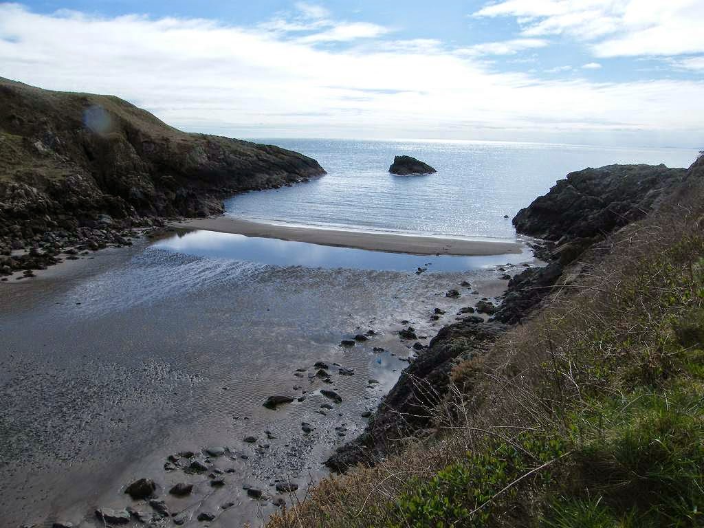
 There were
spectacular views along this rocky bit of coast, back towards the lighthouse
with its redundant foghorn on the edge of the rocks (foghorns are all
electronic these days), and down to beautiful sandy coves.
There were
spectacular views along this rocky bit of coast, back towards the lighthouse
with its redundant foghorn on the edge of the rocks (foghorns are all
electronic these days), and down to beautiful sandy coves.
 And for once there were a lot of people
about, all enjoying the fine views with us.
And for once there were a lot of people
about, all enjoying the fine views with us.
 We climbed — there seemed to be a lot of
uphill.
We climbed — there seemed to be a lot of
uphill.
 Then it was quite a smooth path
for a while. We came to a gully where we
were overlooking a beach far below. I
was feeling really tired, so I sat on a stile to eat my apple. Trouble was, I had to get up every time
someone wanted to get past! So we
descended the steep and very uneven steps down to the beach — Colin had to help
me as I still lack confidence on steep downward slopes.
Then it was quite a smooth path
for a while. We came to a gully where we
were overlooking a beach far below. I
was feeling really tired, so I sat on a stile to eat my apple. Trouble was, I had to get up every time
someone wanted to get past! So we
descended the steep and very uneven steps down to the beach — Colin had to help
me as I still lack confidence on steep downward slopes.
 We went across the beach where a family were
playing, up over rocks, then down better steps to another beach.
We went across the beach where a family were
playing, up over rocks, then down better steps to another beach.
 On the further side of this beach we climbed
a steep zigzag path to get up again.
On the further side of this beach we climbed
a steep zigzag path to get up again.
 Coastal walking is knackering!
There was a seat near the top, so we sat on it and ate a second bar of
chocolate each.
Coastal walking is knackering!
There was a seat near the top, so we sat on it and ate a second bar of
chocolate each.
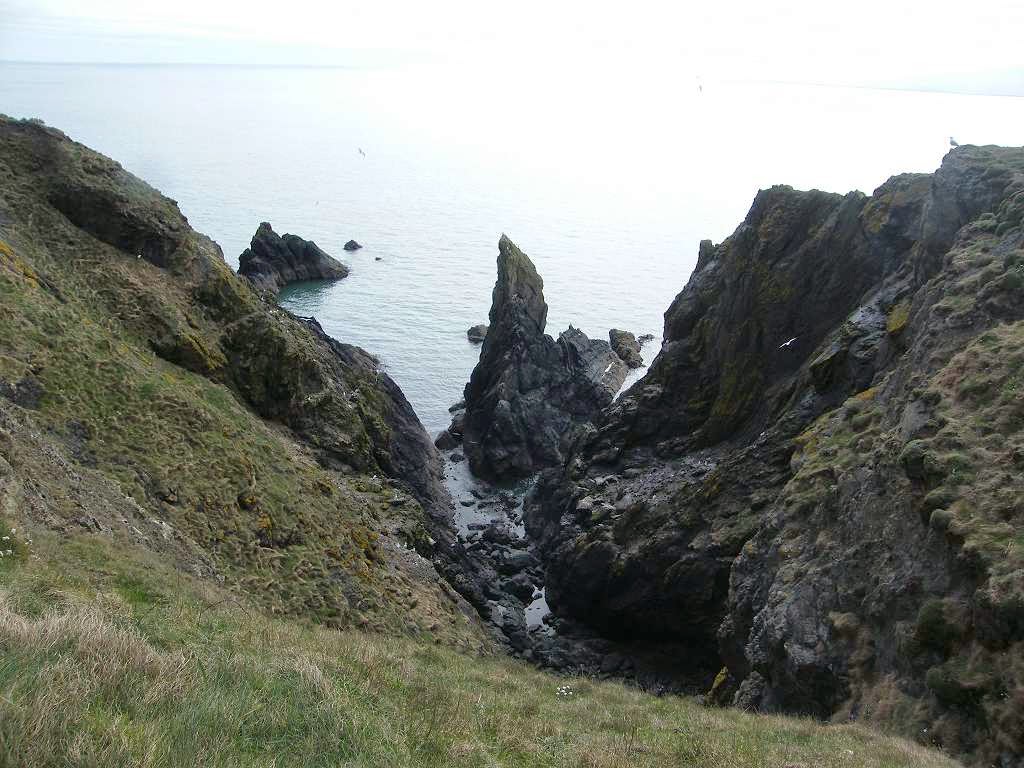
 We continued on the level for a while, with views of
amazing rocks down to our right.
We continued on the level for a while, with views of
amazing rocks down to our right.
 We were
alongside a golf course — the people playing golf on this one were talking in
posh English accents so we guessed it was an expensive course! We passed the radio masts we had been seeing
on the horizon for ages. We came to a
pair of ornate stone gateposts, but our path was arrowed past them still on the
clifftop.
We were
alongside a golf course — the people playing golf on this one were talking in
posh English accents so we guessed it was an expensive course! We passed the radio masts we had been seeing
on the horizon for ages. We came to a
pair of ornate stone gateposts, but our path was arrowed past them still on the
clifftop.
 At last we overlooked Portpatrick, a pretty touristy
fishing village. The path was gravelled by
now, and of very good quality. There
were also more people than ever about on this lovely afternoon.
At last we overlooked Portpatrick, a pretty touristy
fishing village. The path was gravelled by
now, and of very good quality. There
were also more people than ever about on this lovely afternoon.

 We descended the concrete steps into the
village, reading the geology ‘lessons’ printed on every step. We also noticed dogs’ footprints on many of
the steps, obviously made when the concrete was still soft, and a few human
footprints too. It put us in mind of our
eldest grandson, Jamie, when he was twelve.
A new path was concreted at his school on the day they broke up for the
Christmas holidays, when all the kids were mad with excitement anyway. What twelve-year-old could resist soft
concrete? He, among others, left his
footprints forever on that path!
We descended the concrete steps into the
village, reading the geology ‘lessons’ printed on every step. We also noticed dogs’ footprints on many of
the steps, obviously made when the concrete was still soft, and a few human
footprints too. It put us in mind of our
eldest grandson, Jamie, when he was twelve.
A new path was concreted at his school on the day they broke up for the
Christmas holidays, when all the kids were mad with excitement anyway. What twelve-year-old could resist soft
concrete? He, among others, left his
footprints forever on that path!
 The
teachers went ballistic! But I maintain
they asked for it — why couldn’t they have waited until the following day, when
no children were around, to concrete the path?
I thought the incident was quite amusing, and that the teachers
over-reacted on those poor kids — and I taught in a comprehensive school for
sixteen years so I know what ratbags they can be at age twelve.
The
teachers went ballistic! But I maintain
they asked for it — why couldn’t they have waited until the following day, when
no children were around, to concrete the path?
I thought the incident was quite amusing, and that the teachers
over-reacted on those poor kids — and I taught in a comprehensive school for
sixteen years so I know what ratbags they can be at age twelve.
Location: Stranraer to Portpatrick.
Distance: 13 miles.
Total distance: 2813 miles.
Terrain: Concrete. Stony beach. Quiet roads. A cliff path. Undulating, especially the cliff path.
Tide: In, going out.
Rivers: None.
Ferries: None.
Piers: None.
Kissing gates: Nos.260 to 262, all on the cliff path just beyond the lighthouse.
Pubs: None.
‘Historic Scotland’ properties: None.
Ferris wheels: None.
Diversions: No.62 round renovations at Stranraer.
How we got there and back: We were staying in our caravan on a site at New England Bay on the South Rhins. This morning we drove to Portpatrick and parked by the harbour. Then we caught a bus from the village to Stranraer.
At the end we were at the car. We drove back to our caravan at New England Bay where we had our tea and biscuits.
There was still a warning notice about the waves from ferries up to 30 minutes after the ferry had gone past. We looked across the bay — the ferries seemed a long way away.

Before we reached the river at Soleburn Bridge, we went up to the road. We’d had enough. The tide was in, the narrow beach was stony and there obviously was no path. We abandoned our original plan of walking along the beach to Kirkholme and back along the shore — this decision saved us seven miles! The rest of North Rhins is dead ends, very few of which actually lead to the coastline. So we turned south on the road and headed for Portpatrick. We looked back as we climbed the gentle hill, and we could see the P&O ferry leaving for Ireland.
On a gentler side, there were lots of newborn lambs in the fields. We sat on a tree stump near a wood to eat our sarnies. It got warmer when we were down low so we started peeling off the layers.


No comments:
Post a Comment