Weather: A cold start and finish. It was cold in the wind but there was a lot
of sunshine. It was really warm where
there was no wind.
Location: Monreith to Garlieston.
Distance: 23 miles! (When I planned this Walk I thought it would be 17 miles, but we discovered a number of brand new coastal paths along the clifftops which weren’t marked on the latest OS maps — I don’t know why we buy them! — which extended the Walk by six miles! (Oh, and we also went wrong a couple of times!)
Total distance: 2893 miles.
Terrain: A lot of quiet roads. We also walked on tracks and undulating cliff paths.
Tide: In, going out.
Rivers: None.
Ferries: None.
Piers: None.
Kissing gates: Nos.274 to 289 on the cliff path from the cave to Isle of Whithorn. No. 290 at the ruined chapel. Nos.291 to 297 on the new coastal path towards Garlieston — until we turned off it because it got too dark. Twenty-four total has beaten all records for a Walk!
Pubs: ‘The Steam Packet’ at Isle of Whithorn. An excellent pub which we visited several
times, not only on the Walk. Colin
enjoyed Fyne Ales ‘Jarl’, ‘Cobbler Stout’, ‘Maverick’ and Houston ‘IPA’ among
others. I drank Magners cider, a local
cider called ‘Thistly’ something, and Fentiman’s ginger beer. Their pub lunches were ACE!
‘Historic Scotland’ properties: No.34, St Ninian’s Cave. No.35, St Ninian’s Chapel.
Ferris wheels: None.
Diversions: None.
How we got there and back: We were staying in our caravan on a site in Garlieston. This morning we caught a bus in the village to Monreith where we alighted at the top of the beach steps exactly where we had finished the last Walk.
At the end we were at the caravan. It was already dark.
I already had a blister on my left heel, but I had put a fresh ‘Compeed’ plaster over it this morning and hoped it would be OK for the day.
 We marched through the tiny village of Monreith
on the road. A notice told us that it
was originally named ‘Milltown of Monreith’ after the many mills powered by the
local burn. The mill workers lived in
the village. We encountered little
traffic. A milepost just beyond the
village told us it was two miles back to Port William, when we knew for a fact
it was three! As on the last Walk, we
felt all these mileposts had been misplaced.
We marched through the tiny village of Monreith
on the road. A notice told us that it
was originally named ‘Milltown of Monreith’ after the many mills powered by the
local burn. The mill workers lived in
the village. We encountered little
traffic. A milepost just beyond the
village told us it was two miles back to Port William, when we knew for a fact
it was three! As on the last Walk, we
felt all these mileposts had been misplaced.
 There were loads of daffodils by the wayside, but
they were mostly finished by now. The
narcissus were nice though.
There were loads of daffodils by the wayside, but
they were mostly finished by now. The
narcissus were nice though.
We crossed an overgrown stream which we would hardly have seen if it wasn’t for a Council notice on the bridge telling us it had been strengthened using European dosh. So there are some advantages of belonging to the EU then!
 We passed a footpath off towards the sea signposted
‘Maxwell’s Otter’. Apparently Gavin
Maxwell, who wrote ‘Ring of Bright Water’, used to walk his tame otter on the
beach at Monreith. In his memory a
bronze sculpture of an otter has been erected on a rock down there. We would have liked to have seen it, but it
was a dead end and knowing we had a long Walk ahead of us — though we had
under-estimated just how long — we couldn’t spare the time to divert.
We passed a footpath off towards the sea signposted
‘Maxwell’s Otter’. Apparently Gavin
Maxwell, who wrote ‘Ring of Bright Water’, used to walk his tame otter on the
beach at Monreith. In his memory a
bronze sculpture of an otter has been erected on a rock down there. We would have liked to have seen it, but it
was a dead end and knowing we had a long Walk ahead of us — though we had
under-estimated just how long — we couldn’t spare the time to divert.
 We walked under a rookery which spanned the
road. Colin clapped his hands, and the
birds took off with a cacophony of squawking!
I said I wished I’d had my camera out and taken a video of them doing
that. Colin said he would do it again,
but the birds weren’t nearly so noisy the second time and the video was a bit
of a flop!
We walked under a rookery which spanned the
road. Colin clapped his hands, and the
birds took off with a cacophony of squawking!
I said I wished I’d had my camera out and taken a video of them doing
that. Colin said he would do it again,
but the birds weren’t nearly so noisy the second time and the video was a bit
of a flop!
 We pressed on.
We passed an animal park where a number of ponies trotted across the
field to greet us. We also passed a
couple more misplaced milestones.
We pressed on.
We passed an animal park where a number of ponies trotted across the
field to greet us. We also passed a
couple more misplaced milestones.
 We had driven along this road a few times in recent
days, and this morning we came along it in the bus. I had noted a derelict lodge, once the proud
entrance to a big estate, and had got it so fixed in my mind that it was the
place we turned off the road that I didn’t study the map carefully enough. Even when we passed a farm clearly labelled
‘Low Craiglemine’, I thought “It won’t be long now!”
We had driven along this road a few times in recent
days, and this morning we came along it in the bus. I had noted a derelict lodge, once the proud
entrance to a big estate, and had got it so fixed in my mind that it was the
place we turned off the road that I didn’t study the map carefully enough. Even when we passed a farm clearly labelled
‘Low Craiglemine’, I thought “It won’t be long now!”

Further on I said, “It must be further than I thought!” still convinced that it was the derelict lodge where we left the road.
 At last we came to it — yes, the building was in a sad
state with no roof and trees growing up inside.
Colin couldn’t resist going in, he would! I said, “Look out of one of the windows and
I’ll take your photo!” He answered, “I
can’t, the floor over the cellar has gone!”
At last we came to it — yes, the building was in a sad
state with no roof and trees growing up inside.
Colin couldn’t resist going in, he would! I said, “Look out of one of the windows and
I’ll take your photo!” He answered, “I
can’t, the floor over the cellar has gone!”
 We followed the track which was once the driveway to
this old estate, whatever it was. It was
a bit muddy, but we coped. We passed
some pheasant feeding stations, though there were no signs of any pheasants
about. We came to a field gateway where
we sat on a log and ate our pizza/pie.
We followed the track which was once the driveway to
this old estate, whatever it was. It was
a bit muddy, but we coped. We passed
some pheasant feeding stations, though there were no signs of any pheasants
about. We came to a field gateway where
we sat on a log and ate our pizza/pie.
It was then that we realised we were in the wrong place! This track finished at the field gateway — we should have turned off at Low Craiglemine Farm further back. Colin was keen to yomp across the fields and catch up with the track we were supposed to be on further along. I wasn’t — you never know what hazards you come across doing that, and I didn’t want to have to climb through a hedge or over a barbed wire fence at the other end.

Colin hates retracing his steps (so do I, for that matter) but I managed to persuade him to backtrack just as far as the lodge, then continue along the road for another mile or so until we came to another track leading down to the one we should have been on. He made a lot of fuss about it being ‘further’, but he did it!

Back on the correct path, we twisted through woods with ivy-covered trees — not well managed these days, obviously. There were also some exotic specimens brought from foreign parts, but now neglected.
 We came out to open fields and a derelict farm
buildings — I mean really derelict as
in falling down. Yet the fields either
side of us were well used. A good track
between the fields for about a mile led us to another small wood. And there we came across yet another derelict building, a small
cottage. Doesn’t anyone live in these
parts anymore?
We came out to open fields and a derelict farm
buildings — I mean really derelict as
in falling down. Yet the fields either
side of us were well used. A good track
between the fields for about a mile led us to another small wood. And there we came across yet another derelict building, a small
cottage. Doesn’t anyone live in these
parts anymore?
 We went downhill to a nice stream and a pretty
waterfall. It was lovely with the sun
shining through the trees which were not quite in leaf yet — a dappled effect.
We went downhill to a nice stream and a pretty
waterfall. It was lovely with the sun
shining through the trees which were not quite in leaf yet — a dappled effect.

 We came out on to the track leading from a
car park to the cave on the beach, which we had recced yesterday on our ‘rest’
day.
We came out on to the track leading from a
car park to the cave on the beach, which we had recced yesterday on our ‘rest’
day.
Then we made a second navigational error. Yesterday we had walked down this track to the beach to look at St Ninian’s Cave, and to recce out how we could connect with the coastal path towards Whithorn which wasn’t very clear on the map.

 The tiny cave at the western end of the beach
is little more than a dent in the cliffs, but it was reputedly used as a place
for personal prayer in the fifth century by St Ninian, the first Christian
missionary to Scotland. In medieval times, pilgrims would stop off
here to pray on their way to St Ninian’s shrine on the Isle of Whithorn. Even in the 1950s there were decorated stones
inside the cave — they have since been removed to a museum. But we found a crude wooden cross outside, so
the cave is still revered by some.
The tiny cave at the western end of the beach
is little more than a dent in the cliffs, but it was reputedly used as a place
for personal prayer in the fifth century by St Ninian, the first Christian
missionary to Scotland. In medieval times, pilgrims would stop off
here to pray on their way to St Ninian’s shrine on the Isle of Whithorn. Even in the 1950s there were decorated stones
inside the cave — they have since been removed to a museum. But we found a crude wooden cross outside, so
the cave is still revered by some.
 As we left the beach, we failed to walk right along
to the eastern end. If we had we would
have seen the rough path leading up to the clifftop, but we had become
convinced that the way to connect with the coastal path was to turn off the
track at a ‘Beware of Bulls’ notice which was partway down, cross a stream
and go round behind an ancient fort. So
that is what we did today — we didn’t even go down as far as the beach.
As we left the beach, we failed to walk right along
to the eastern end. If we had we would
have seen the rough path leading up to the clifftop, but we had become
convinced that the way to connect with the coastal path was to turn off the
track at a ‘Beware of Bulls’ notice which was partway down, cross a stream
and go round behind an ancient fort. So
that is what we did today — we didn’t even go down as far as the beach.
 But we were wrong! Round behind the fort the path
disappeared. (We met no bulls, by the way.) We walked along next to a wall looking for a
way through, but there wasn’t one. Colin
climbed over the wall and found a way down through gorse bushes to a
track. I followed, partially demolishing
the wall as I climbed over! We thought
we were there, but as we advanced along the track we realised we weren’t. We could see a signpost on the coastal path,
so at least we knew it existed (you never know in Scotland), but there was a
water-filled ditch between it and us which was too wide to jump. The ditch went under a barbed wire fence, and
there was a pheasant-shooters stile over said fence. We climbed over — it was a bit dodgy — and
came to a place where the ditch was much narrower. We could jump over it, but only if we landed
in impenetrable brambles or wall-to-wall gorse!
Colin found a way through the gorse, and I followed him — this involved
climbing a vertical slope. What
a mess we had got ourselves into!
At last we came to a kissing gate on the coastal path — but realised, to
our horror, that we were at the wrong corner.
At the point of the gate we had to climb over the fence which was topped
with barbed wire.
But we were wrong! Round behind the fort the path
disappeared. (We met no bulls, by the way.) We walked along next to a wall looking for a
way through, but there wasn’t one. Colin
climbed over the wall and found a way down through gorse bushes to a
track. I followed, partially demolishing
the wall as I climbed over! We thought
we were there, but as we advanced along the track we realised we weren’t. We could see a signpost on the coastal path,
so at least we knew it existed (you never know in Scotland), but there was a
water-filled ditch between it and us which was too wide to jump. The ditch went under a barbed wire fence, and
there was a pheasant-shooters stile over said fence. We climbed over — it was a bit dodgy — and
came to a place where the ditch was much narrower. We could jump over it, but only if we landed
in impenetrable brambles or wall-to-wall gorse!
Colin found a way through the gorse, and I followed him — this involved
climbing a vertical slope. What
a mess we had got ourselves into!
At last we came to a kissing gate on the coastal path — but realised, to
our horror, that we were at the wrong corner.
At the point of the gate we had to climb over the fence which was topped
with barbed wire.
 We were there — really really there at last! We watched as a young couple walked calmly up
from the eastern end of the beach and passed us — aaarrgh!!
We were there — really really there at last! We watched as a young couple walked calmly up
from the eastern end of the beach and passed us — aaarrgh!!
 The path was quite difficult at first. This bit was not marked on the OS map which
was why we had got ourselves into such a pickle. We sat down out of the wind to eat our
sarnies. My blister was giving me grief
despite the ‘Compeed’ plaster over it, so I added a ‘blister plaster’ to it to
give it more protection.
The path was quite difficult at first. This bit was not marked on the OS map which
was why we had got ourselves into such a pickle. We sat down out of the wind to eat our
sarnies. My blister was giving me grief
despite the ‘Compeed’ plaster over it, so I added a ‘blister plaster’ to it to
give it more protection.
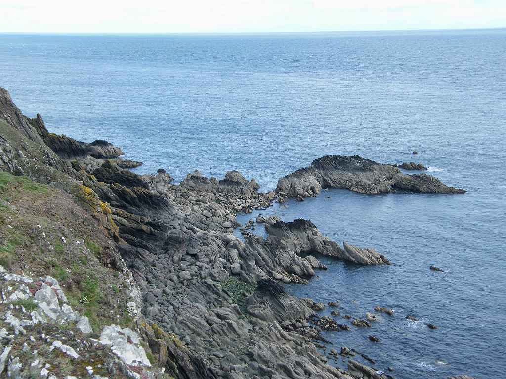
 The path improved when we reached the top of the
cliffs, it got much wider and there was a choice of routes across the
grass. We had magnificent views towards South Rhins and the Isle of Man. Many of the rocks were twisted, and in most
cases the strata was vertical — there had obviously been a lot of movement in
times gone past.
The path improved when we reached the top of the
cliffs, it got much wider and there was a choice of routes across the
grass. We had magnificent views towards South Rhins and the Isle of Man. Many of the rocks were twisted, and in most
cases the strata was vertical — there had obviously been a lot of movement in
times gone past.

 At the most southerly point of this peninsula we came
to a caravan site. This was the only
part of the coastal path where we met other people, apart from that couple who
had walked so nonchalantly up from St Ninian’s Cave beach.
At the most southerly point of this peninsula we came
to a caravan site. This was the only
part of the coastal path where we met other people, apart from that couple who
had walked so nonchalantly up from St Ninian’s Cave beach.
 There were fishermen on the shore, and a
memorial seat covered in flowers. It was
in memory of someone called Peter Brannigan who lived locally and died aged
only thirty-three. “And his beloved
Shane” we assumed referred to his dog — we wondered if there had been a tragic
accident on the cliffs involving the dog.
There were fishermen on the shore, and a
memorial seat covered in flowers. It was
in memory of someone called Peter Brannigan who lived locally and died aged
only thirty-three. “And his beloved
Shane” we assumed referred to his dog — we wondered if there had been a tragic
accident on the cliffs involving the dog.
We were a bit disappointed with a signpost which told us we were not yet halfway between the Cave and Whithorn — we were already feeling quite tired and felt we had walked a lot further than it said we had. The blister on my heel was still giving me grief, so I took some painkillers.

 There were amazing rocks at this site. It wasn’t easy to find our way through the
caravans, but we coped and continued towards Whithorn. We said “Goodbye!” to South Rhins, and caught
our first sight of the Lake District (England!), but it was very misty
and couldn’t be photographed. We continued
up towards a Second World War look-out post.
There were amazing rocks at this site. It wasn’t easy to find our way through the
caravans, but we coped and continued towards Whithorn. We said “Goodbye!” to South Rhins, and caught
our first sight of the Lake District (England!), but it was very misty
and couldn’t be photographed. We continued
up towards a Second World War look-out post.
 After a smooth mown patch the path got bumpy again,
but later it was flat along the edge of fields for ages. (This part of the coastal path did not appear
on the OS map.) We caught sight of the
Isle of Whithorn, and then the village
of Whithorn — it looked
glorious in the sunshine. The path
followed closely along the shore, going through parkland and even over a new
footbridge before reaching the village.
After a smooth mown patch the path got bumpy again,
but later it was flat along the edge of fields for ages. (This part of the coastal path did not appear
on the OS map.) We caught sight of the
Isle of Whithorn, and then the village
of Whithorn — it looked
glorious in the sunshine. The path
followed closely along the shore, going through parkland and even over a new
footbridge before reaching the village.


We passed a very attractive planter with a wall decoration. Beyond the Post Office we sat on a bench to eat our apples. We walked past a row of colour-washed houses, one of which was shocking pink!
 We
passed the pub (brave!) and continued
on to the Isle of Whithorn to look at the ruined chapel. The ruins we were exploring date from about
1300, but this chapel replaced an earlier one on the site. Since about the 5th century
pilgrims have flocked to this remote peninsula, enduring many hardships as they
travelled over land and sea. They were followers
of St Ninian who built a church here, was Bishop of the area and died here in
431.
We
passed the pub (brave!) and continued
on to the Isle of Whithorn to look at the ruined chapel. The ruins we were exploring date from about
1300, but this chapel replaced an earlier one on the site. Since about the 5th century
pilgrims have flocked to this remote peninsula, enduring many hardships as they
travelled over land and sea. They were followers
of St Ninian who built a church here, was Bishop of the area and died here in
431.
 Nearby was a pile of stones with writing on each one. They commemorate people’s loved ones who have
died — parents, spouses, siblings, children, stillborn babies, friends, even
pets — and more are placed there every day.
A polished granite stone had this message on it: The Witness Cairn / Celebrating St Ninian 397 to 1997 /
Inaugurated 11th May 1997 / Dear visitor pilgrim, you are invited to add your
own stone to this cairn as a symbol of an act of witness which you have
completed or which you now pledge.
It was difficult to read because it was written in an odd script, but
the last bit was something about Churches Together in Scotland in
co-operation with the people of Whithorn and the Isle.
Nearby was a pile of stones with writing on each one. They commemorate people’s loved ones who have
died — parents, spouses, siblings, children, stillborn babies, friends, even
pets — and more are placed there every day.
A polished granite stone had this message on it: The Witness Cairn / Celebrating St Ninian 397 to 1997 /
Inaugurated 11th May 1997 / Dear visitor pilgrim, you are invited to add your
own stone to this cairn as a symbol of an act of witness which you have
completed or which you now pledge.
It was difficult to read because it was written in an odd script, but
the last bit was something about Churches Together in Scotland in
co-operation with the people of Whithorn and the Isle.

Another granite stone was a memorial In memory of the local men who died at the sinking of the fishing vessel “Solway Harvester” off the South-East coast of the Isle-of-Man on the 11th January 2000. Seven names were listed alongside their ages — three of them were teenagers and the eldest was only 33.
 We take the fish on our plates
so much for granted, yet fishing is one of the most dangerous jobs on the
planet. It is right that we should
commemorate these brave men and boys.
We take the fish on our plates
so much for granted, yet fishing is one of the most dangerous jobs on the
planet. It is right that we should
commemorate these brave men and boys.
 Then we went to the pub! We had been to this pub a couple of times
before on our ‘rest’ days because they do fantastic lunches at very reasonable
prices, and the ale is first class with a range of beers and ciders from which to
choose. (It is in the CAMRA ‘Good Beer
Guide’, of course.) Today we just
stopped off for a drink as we still had seven miles to walk back to
Garlieston. There was an obese couple
sitting near us — absolutely grotesque in size!
On the News this morning they were discussing a plan to ban the
advertising of junk food because the obesity problem is bankrupting the
National Health Service. I know I still
need to lose a few pounds, but I just can’t understand how anyone can allow
themselves to get morbidly obese. They
must feel awful all the time, and they look dreadful too.
Then we went to the pub! We had been to this pub a couple of times
before on our ‘rest’ days because they do fantastic lunches at very reasonable
prices, and the ale is first class with a range of beers and ciders from which to
choose. (It is in the CAMRA ‘Good Beer
Guide’, of course.) Today we just
stopped off for a drink as we still had seven miles to walk back to
Garlieston. There was an obese couple
sitting near us — absolutely grotesque in size!
On the News this morning they were discussing a plan to ban the
advertising of junk food because the obesity problem is bankrupting the
National Health Service. I know I still
need to lose a few pounds, but I just can’t understand how anyone can allow
themselves to get morbidly obese. They
must feel awful all the time, and they look dreadful too.
It was after 5pm when we set out to yomp to Garlieston, about seven miles and mostly along roads we thought. I took some more painkillers because my heel was still feeling sore. We set up quite a pace because ‘route-marching’ is the only way when fatigue sets in.
 About two miles out we came to a signpost pointing
across a field towards the sea. It said,
“Coastal path to Garlieston, 6 miles”.
Eh? That meant it was eight miles from Whithorn to Garlieston,
not seven as I had measured from the map.
And there was no vestige of this footpath printed on our oh-so-expensive
up-to-date OS map! We dithered for a
minute or two, then decided to risk it.
Neither of us like walking on roads — though these ones were very quiet —
and our original Rule no.1 says we must take the “nearest safe path to the coast”.
About two miles out we came to a signpost pointing
across a field towards the sea. It said,
“Coastal path to Garlieston, 6 miles”.
Eh? That meant it was eight miles from Whithorn to Garlieston,
not seven as I had measured from the map.
And there was no vestige of this footpath printed on our oh-so-expensive
up-to-date OS map! We dithered for a
minute or two, then decided to risk it.
Neither of us like walking on roads — though these ones were very quiet —
and our original Rule no.1 says we must take the “nearest safe path to the coast”.
The first signpost pointed us across a field towards the sea, and from then on we walked a route within sight of the shore which was nice. There were lots of kissing gates, all brand new. But the path itself was difficult to see because it was not well walked. After passing through a kissing gate, we had to look ahead to see where the next one was and make towards it. Because of the undulations in the terrain it was not always possible to see it straight away, so we just had to guess until we spied it.
Of course, our progress was much slower than when we were on the road — no hope of ‘route-marching’ here. The sun was sinking low and we still had several miles to go. The path was uneven, the gates were in obscure places and there was plenty to trip over if we weren’t careful. We were tired, and we knew it would be foolhardy to hurry under those circumstances.
 There were plenty of hazards — like
earthworks and World War II concrete constructions — and we felt it was not the
place to be after dark. After about two
miles we came to the top of a rise and I voiced my misgivings. We had no hope of getting back to Garlieston
before dark, especially as the last couple of miles past Rigg Bay
would be through a wood. So we decided
to ditch the coastal path, and worked out a way of getting back to the road.
There were plenty of hazards — like
earthworks and World War II concrete constructions — and we felt it was not the
place to be after dark. After about two
miles we came to the top of a rise and I voiced my misgivings. We had no hope of getting back to Garlieston
before dark, especially as the last couple of miles past Rigg Bay
would be through a wood. So we decided
to ditch the coastal path, and worked out a way of getting back to the road.
We went back one field so we could get through a gate, then followed a stream up to a farm. We guessed the farmhouse must have access to the road, but when we got there we couldn’t get out of the field. We made our way round to the other side of the house where we found a gate, but this just led into another field. We followed the fence along, and came to another gate with an electric fence running along the top of it. Colin carefully unplugged this while I opened the gate. We both slipped through, then I closed the gate and Colin plugged in the electric fence again! It was a few yards to another gate — no electric fence this time — and we were on a trackway out to the road.
 Then we really hoofed it, easy when walking on
tarmac. Traffic was negligible. We saw a fox in a field, and a cow with two
very young calves in another — a quick “Aah!” and on we went! We sat on a wall by Cruggleton church to eat
chocolate.
Then we really hoofed it, easy when walking on
tarmac. Traffic was negligible. We saw a fox in a field, and a cow with two
very young calves in another — a quick “Aah!” and on we went! We sat on a wall by Cruggleton church to eat
chocolate.
 A couple of days later we
came back to look at this church which is all by itself in a field but
surrounded by trees. It is very old — I
wonder what happened to the village it served? — and had been restored by the
Victorians. After negotiating a very
muddy path to get to the door we found it was locked! So we never did find out what it was like
inside.
A couple of days later we
came back to look at this church which is all by itself in a field but
surrounded by trees. It is very old — I
wonder what happened to the village it served? — and had been restored by the
Victorians. After negotiating a very
muddy path to get to the door we found it was locked! So we never did find out what it was like
inside.
We marched on, ignoring a track to Rigg Bay which we passed just as the sun was setting behind a hill. If only it had been daylight — that would have been a lovely walk! After that it got dark very quickly, but we didn’t lose our way because we were on the road. We had been wise to leave the coastal path when we did. We made up a new rule to suit these circumstances: “If it is getting dark and we are in danger of still being on a coastal path when we can no longer see where we are going, then we may cut across to the nearest road in the interests of safety.” By the time we had entered Garlieston and got back to our caravan, it was pitch dark.
That ended Walk no.290, we shall pick up Walk no.291 next time at our caravan in Garlieston. It was half-past eight, so the Walk had taken us twelve and a half hours! We were exhausted, but we made some tea and heated up a big pizza for our supper before falling into bed.
 The next day was a ‘rest’ day, and we felt we had
been ‘cheated’ out of a pleasant walk through the woods at the end of Walk
290. So we decided to walk from the
caravan to Rigg Bay and back in the sunshine.
The next day was a ‘rest’ day, and we felt we had
been ‘cheated’ out of a pleasant walk through the woods at the end of Walk
290. So we decided to walk from the
caravan to Rigg Bay and back in the sunshine.
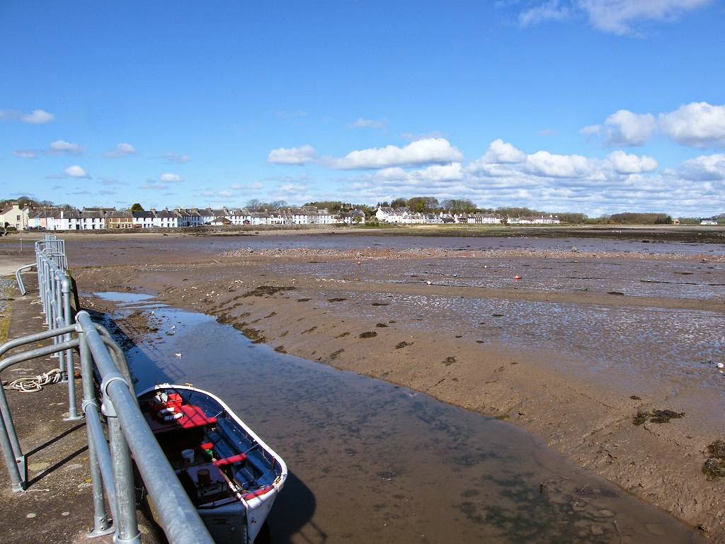
 We walked past the harbour, which was a bit dry
because the tide was out. A ship’s
anchor was left on the side as an ornament.
Soon we passed through a gate on which there was a notice telling us
this was the coastal path — one mile to Rigg Bay
and seven to Whithorn. The path from
thereon was flat, easy walking and very pleasant with the sunshine filtering
through the trees.
We walked past the harbour, which was a bit dry
because the tide was out. A ship’s
anchor was left on the side as an ornament.
Soon we passed through a gate on which there was a notice telling us
this was the coastal path — one mile to Rigg Bay
and seven to Whithorn. The path from
thereon was flat, easy walking and very pleasant with the sunshine filtering
through the trees.
 There were bluebells in the woods to our right, and
we saw a heron fishing in the shallows to our left. We heard and saw a woodpecker. We sauntered along revelling in the fact that
we didn’t have to get to a certain point in a certain time. It was very relaxing.
There were bluebells in the woods to our right, and
we saw a heron fishing in the shallows to our left. We heard and saw a woodpecker. We sauntered along revelling in the fact that
we didn’t have to get to a certain point in a certain time. It was very relaxing.
 Further on we could see a manor house to our
right. We had passed the entrance to
this on the road last night in the dark.
It looked a grand house, and we wondered if a family still lived in it.
Further on we could see a manor house to our
right. We had passed the entrance to
this on the road last night in the dark.
It looked a grand house, and we wondered if a family still lived in it.
 On reaching Rigg Bay,
we turned round and sauntered back. It
was a nice little stroll, very enjoyable.
On reaching Rigg Bay,
we turned round and sauntered back. It
was a nice little stroll, very enjoyable.
 Pity we had to miss out about four miles of coastal path last night
because darkness overcame us. We should
have divided Walk 290 into two Walks, then we could have enjoyed them both in
daylight.
Pity we had to miss out about four miles of coastal path last night
because darkness overcame us. We should
have divided Walk 290 into two Walks, then we could have enjoyed them both in
daylight.

‘Historic Scotland’ properties: No.34, St Ninian’s Cave. No.35, St Ninian’s Chapel.
Ferris wheels: None.
Diversions: None.
How we got there and back: We were staying in our caravan on a site in Garlieston. This morning we caught a bus in the village to Monreith where we alighted at the top of the beach steps exactly where we had finished the last Walk.
At the end we were at the caravan. It was already dark.
I already had a blister on my left heel, but I had put a fresh ‘Compeed’ plaster over it this morning and hoped it would be OK for the day.
We crossed an overgrown stream which we would hardly have seen if it wasn’t for a Council notice on the bridge telling us it had been strengthened using European dosh. So there are some advantages of belonging to the EU then!
Further on I said, “It must be further than I thought!” still convinced that it was the derelict lodge where we left the road.
It was then that we realised we were in the wrong place! This track finished at the field gateway — we should have turned off at Low Craiglemine Farm further back. Colin was keen to yomp across the fields and catch up with the track we were supposed to be on further along. I wasn’t — you never know what hazards you come across doing that, and I didn’t want to have to climb through a hedge or over a barbed wire fence at the other end.
Colin hates retracing his steps (so do I, for that matter) but I managed to persuade him to backtrack just as far as the lodge, then continue along the road for another mile or so until we came to another track leading down to the one we should have been on. He made a lot of fuss about it being ‘further’, but he did it!
Back on the correct path, we twisted through woods with ivy-covered trees — not well managed these days, obviously. There were also some exotic specimens brought from foreign parts, but now neglected.

Then we made a second navigational error. Yesterday we had walked down this track to the beach to look at St Ninian’s Cave, and to recce out how we could connect with the coastal path towards Whithorn which wasn’t very clear on the map.

We were a bit disappointed with a signpost which told us we were not yet halfway between the Cave and Whithorn — we were already feeling quite tired and felt we had walked a lot further than it said we had. The blister on my heel was still giving me grief, so I took some painkillers.
We passed a very attractive planter with a wall decoration. Beyond the Post Office we sat on a bench to eat our apples. We walked past a row of colour-washed houses, one of which was shocking pink!

Another granite stone was a memorial In memory of the local men who died at the sinking of the fishing vessel “Solway Harvester” off the South-East coast of the Isle-of-Man on the 11th January 2000. Seven names were listed alongside their ages — three of them were teenagers and the eldest was only 33.
It was after 5pm when we set out to yomp to Garlieston, about seven miles and mostly along roads we thought. I took some more painkillers because my heel was still feeling sore. We set up quite a pace because ‘route-marching’ is the only way when fatigue sets in.
The first signpost pointed us across a field towards the sea, and from then on we walked a route within sight of the shore which was nice. There were lots of kissing gates, all brand new. But the path itself was difficult to see because it was not well walked. After passing through a kissing gate, we had to look ahead to see where the next one was and make towards it. Because of the undulations in the terrain it was not always possible to see it straight away, so we just had to guess until we spied it.
Of course, our progress was much slower than when we were on the road — no hope of ‘route-marching’ here. The sun was sinking low and we still had several miles to go. The path was uneven, the gates were in obscure places and there was plenty to trip over if we weren’t careful. We were tired, and we knew it would be foolhardy to hurry under those circumstances.
We went back one field so we could get through a gate, then followed a stream up to a farm. We guessed the farmhouse must have access to the road, but when we got there we couldn’t get out of the field. We made our way round to the other side of the house where we found a gate, but this just led into another field. We followed the fence along, and came to another gate with an electric fence running along the top of it. Colin carefully unplugged this while I opened the gate. We both slipped through, then I closed the gate and Colin plugged in the electric fence again! It was a few yards to another gate — no electric fence this time — and we were on a trackway out to the road.
We marched on, ignoring a track to Rigg Bay which we passed just as the sun was setting behind a hill. If only it had been daylight — that would have been a lovely walk! After that it got dark very quickly, but we didn’t lose our way because we were on the road. We had been wise to leave the coastal path when we did. We made up a new rule to suit these circumstances: “If it is getting dark and we are in danger of still being on a coastal path when we can no longer see where we are going, then we may cut across to the nearest road in the interests of safety.” By the time we had entered Garlieston and got back to our caravan, it was pitch dark.
That ended Walk no.290, we shall pick up Walk no.291 next time at our caravan in Garlieston. It was half-past eight, so the Walk had taken us twelve and a half hours! We were exhausted, but we made some tea and heated up a big pizza for our supper before falling into bed.
Codicil


No comments:
Post a Comment