Weather: Quite sunny.
It was cold in the wind, warm out of it.
There were occasional light showers but they didn’t ever come to
anything much.
Location: New England Bay to Glenluce.
Distance: 16 miles.
Total distance: 2853 miles.
Terrain: A lot of beach, much of which was stony and therefore not easy walking. A field, which ended with us climbing a barbed wire fence and wall into a wood, and scrambling down a twelve-foot cliff at the end! A lot of road-walking, some quite busy. We ended by crossing a swampy golf course, getting lost, then a nice path through trees by the river. The sting in the tail was that we reached the road bridge over the river but there was no way up to it! So we climbed over a fence, scrambled up a steep bank through hawthorn bushes and stepped over the Armco. A challenging Walk!
Tide: Coming in, then going out.
Rivers: No.344, Piltanton Burn. No.345, Water of Luce.
Ferries: None.
Piers: None.
Kissing gates: None.
Pubs: None.
‘Historic Scotland’ properties: No.31, Glenluce Abbey.
Ferris wheels: None.
Diversions: None.
How we got there and back: We were staying in our caravan on a site at New England Bay on the South Rhins. This morning Colin drove to Glenluce where he parked at the edge of the town. He then caught a bus to Stranraer which linked up (no thanks to ‘Traveline’ who had told us the wrong place!) with a bus to Ardwell. He alighted at a road junction about a mile from the caravan site, and walked the rest. We started the Walk from the caravan.
At the end I waited near the road junction just across the river while Colin nipped into the edge of town to fetch the car. We then drove back to New England Bay.
The next day we moved the caravan to Garlieston.
 We walked out of our caravan and straight on to the
beach. The tide was right out so we had
a lot of beach to walk on. It was
glorious! This is what we should have
been doing on the last Walk.
We walked out of our caravan and straight on to the
beach. The tide was right out so we had
a lot of beach to walk on. It was
glorious! This is what we should have
been doing on the last Walk.
 There was a
lot of firm sand below high water mark, but it didn’t last. As we progressed there were more and more
stones to scramble over, and we began to find the going quite difficult. We struggled on, but we were slow.
There was a
lot of firm sand below high water mark, but it didn’t last. As we progressed there were more and more
stones to scramble over, and we began to find the going quite difficult. We struggled on, but we were slow.

 We got to Logan Mills where we passed a fisherman’s
shack which was festooned with floats and lifebelts. Just beyond that there was a footbridge over
a stream. We might have been glad of
that at high tide, but since the tide was out we were able to paddle across the
braided rivulet where it was very shallow.
We got to Logan Mills where we passed a fisherman’s
shack which was festooned with floats and lifebelts. Just beyond that there was a footbridge over
a stream. We might have been glad of
that at high tide, but since the tide was out we were able to paddle across the
braided rivulet where it was very shallow.

 We passed some farm buildings which looked a bit
neglected. Behind them was a tower which
we thought was a folly at the time. But
our map told us it was the remains of an ancient windmill — we thought it
looked too ornate for that. We sat on a
bank and ate our pasty/pizza slice.
(Pizza for me, pasty for Colin.)
We passed some farm buildings which looked a bit
neglected. Behind them was a tower which
we thought was a folly at the time. But
our map told us it was the remains of an ancient windmill — we thought it
looked too ornate for that. We sat on a
bank and ate our pasty/pizza slice.
(Pizza for me, pasty for Colin.)
 The beach got very stony and we found walking along
this uneven surface absolutely knackering.
Colin climbed up the bank and looked in the adjacent field to see if it
was any better. He said it was, and that
there was a gate at the end of the field so we could get out. So I climbed up the steep bank, we ducked
under an electric fence and walked along the edge of a sweetcorn field. Most of the plants had gone and they had not
been replaced, so it all looked a bit untidy.
The beach got very stony and we found walking along
this uneven surface absolutely knackering.
Colin climbed up the bank and looked in the adjacent field to see if it
was any better. He said it was, and that
there was a gate at the end of the field so we could get out. So I climbed up the steep bank, we ducked
under an electric fence and walked along the edge of a sweetcorn field. Most of the plants had gone and they had not
been replaced, so it all looked a bit untidy.
 There was a bank along the inland side of the field, and in one place we
noticed a sandstone outcrop, like a kind of cliff. We could see the layers of strata, also holes
in the cliff face — we wondered if sand martins nested there in season.
There was a bank along the inland side of the field, and in one place we
noticed a sandstone outcrop, like a kind of cliff. We could see the layers of strata, also holes
in the cliff face — we wondered if sand martins nested there in season.
We came to the gate at the end, but that proved to be no-go. Not only did it have barbed wire along the top, but there were thick gorse bushes pressed up behind it — it obviously hadn’t been opened for years. So we shuffled along a bit to where there were no gorse bushes and carefully climbed over a single strand of barbed wire and a wall into a wood.

 It was very pretty in the wood, with dappled
sunshine filtering through the early leaves.
Wood anemones abounded, and we could see that it would be even prettier
in a few weeks time when the bluebells come out. There were no actual paths, but it was easy
walking under the trees — we really enjoyed it.
Trouble was, there was no way out at the other end. Our only possible exit was down to the beach,
but this involved a scramble down a twelve-foot cliff! We managed it — with difficulty — because it
was soft and we could get footholds.
It was very pretty in the wood, with dappled
sunshine filtering through the early leaves.
Wood anemones abounded, and we could see that it would be even prettier
in a few weeks time when the bluebells come out. There were no actual paths, but it was easy
walking under the trees — we really enjoyed it.
Trouble was, there was no way out at the other end. Our only possible exit was down to the beach,
but this involved a scramble down a twelve-foot cliff! We managed it — with difficulty — because it
was soft and we could get footholds.
 This part of the beach was not quite so stony and we
were able to walk it more easily. We
walked into Ardwell. We were
disappointed because we had been going for two hours and we had only walked two
miles. With a further fourteen miles to
go, we wouldn’t reach the car until the middle of the night at this rate! We quickened our pace.
This part of the beach was not quite so stony and we
were able to walk it more easily. We
walked into Ardwell. We were
disappointed because we had been going for two hours and we had only walked two
miles. With a further fourteen miles to
go, we wouldn’t reach the car until the middle of the night at this rate! We quickened our pace.
 We walked straight past a picnic site. We were amused by a young couple who came out
of there and walked on ahead of us.
There was another stream across the beach. The bloke took off his rucksack and threw it over
the water — then he did a flamboyant leap across, obviously showing off his
masculinity to the girl and to anyone else who happened to be watching. She, meanwhile, stepped her way gingerly
through the stream in a wimpish kind of way and got her feet wet! We went a few yards downstream to where it
was braided and really shallow, then paddled across in just a couple of inches
of water — it didn’t even reach our bootlaces.
Experience, you see!
We walked straight past a picnic site. We were amused by a young couple who came out
of there and walked on ahead of us.
There was another stream across the beach. The bloke took off his rucksack and threw it over
the water — then he did a flamboyant leap across, obviously showing off his
masculinity to the girl and to anyone else who happened to be watching. She, meanwhile, stepped her way gingerly
through the stream in a wimpish kind of way and got her feet wet! We went a few yards downstream to where it
was braided and really shallow, then paddled across in just a couple of inches
of water — it didn’t even reach our bootlaces.
Experience, you see!
 However, in their youth they walked on much more
quickly than us and we soon lost sight of them.
I was still finding the stones difficult, but the views across the water
were very calm and peaceful. We watched
a heron trying its luck in the shallows, but didn’t see it catch anything.
However, in their youth they walked on much more
quickly than us and we soon lost sight of them.
I was still finding the stones difficult, but the views across the water
were very calm and peaceful. We watched
a heron trying its luck in the shallows, but didn’t see it catch anything.
 We came to yet another stream. This was in a deeper channel and quite wide,
so we were grateful for the brand new footbridge which had been laid across
it. We came to a further picnic site
with access to the road. I’d had enough
of that stony beach, so we put on our bright yellow vests and marched along the
road for a bit. We passed a cottage
where an elderly man was sitting outside in the sun. First Colin passed him, then me about thirty
seconds later. He asked, “Is this a
race?” I think it was the yellow vests
that did it!
We came to yet another stream. This was in a deeper channel and quite wide,
so we were grateful for the brand new footbridge which had been laid across
it. We came to a further picnic site
with access to the road. I’d had enough
of that stony beach, so we put on our bright yellow vests and marched along the
road for a bit. We passed a cottage
where an elderly man was sitting outside in the sun. First Colin passed him, then me about thirty
seconds later. He asked, “Is this a
race?” I think it was the yellow vests
that did it!
The road was horrible — quite a bit of traffic and it didn’t slow down when it saw us. We were alongside the beach, and the stone situation seemed to improve. We decided it was the lesser of two evils, so where the road branched away by a cottage we returned to the beach.
The tide was coming in quite fast and there was much less beach to walk on now. We came to a long concrete step past a cottage, and found that was much easier to walk on. All was going well until I trod on a wet bit — it was like ice! My foot slipped down about eighteen inches to a lower level — quick as you like! Fortunately I landed on it absolutely square. It gave me a shock, but there was no harm done. We’d both had visions of me breaking my leg again, and I had to rest a few minutes to compose myself. I was very careful after that, but I found myself disliking the beach even more.
We approached Sandhead. We met two women out walking their dog, and stopped to chat. They told us it was a ‘rescue’ dog which was very tentative in water, so they were trying to get it to feel more comfortable on beach walks.
 We sat on a concrete step, where we were totally out of the wind, to eat
our sarnies. The women and the dog came
back while we were still there, and stopped for more chat.
We sat on a concrete step, where we were totally out of the wind, to eat
our sarnies. The women and the dog came
back while we were still there, and stopped for more chat.
We walked into Sandhead where we saw a tea shop — that’s more like it! It was open six days a week, CLOSED ON TUESDAYS — Aaaaaaaaarrrgh!! (Obviously not our day!)
 We carried on to another
caravan site where there was another spanking new footbridge across a
stream. Colin was a bit ahead of me and
got across, but when I got there a group of people had arrived at the other
side with a blind/disabled man in their midst.
I had to wait while they guided him across.
We carried on to another
caravan site where there was another spanking new footbridge across a
stream. Colin was a bit ahead of me and
got across, but when I got there a group of people had arrived at the other
side with a blind/disabled man in their midst.
I had to wait while they guided him across.
We continued along the beach, but we didn’t want to go too far because we knew we would get stuck on a marsh and an Army bombing range if we did. So we walked through the caravan site towards its entrance. There we found a path off to the side which looked as if it might go along the back of the beach, but it didn’t — it just led us back to where we’d been before. We retraced our steps and walked out on to the road once again. We were on a B-road, just, and most of the traffic stuck to the A-road which led to Stranraer. But what little traffic did come past us came fast because the road was straight.
 We walked through the MOD site of West
Freugh where Colin worked for a few weeks nearly fifty years ago
when he was employed at the RAE (Royal Aircraft Establishment) in Farnborough. West Freugh
still appears to be a working site, but is now apparently run by Qinetiq as is
the RAE and RRE (Royal Radar Establishment) in Malvern.
We walked through the MOD site of West
Freugh where Colin worked for a few weeks nearly fifty years ago
when he was employed at the RAE (Royal Aircraft Establishment) in Farnborough. West Freugh
still appears to be a working site, but is now apparently run by Qinetiq as is
the RAE and RRE (Royal Radar Establishment) in Malvern.
 Colin reminisced about taking three days to
drive up in a draughty lorry because there were no motorways in those
days. But he remembers little about the
work he did up here, except that it was foggy.
He was supposed to be watching out for something they were exploding
over the loch, but he couldn’t see anything except mist so it was a bit of a
waste of time!
Colin reminisced about taking three days to
drive up in a draughty lorry because there were no motorways in those
days. But he remembers little about the
work he did up here, except that it was foggy.
He was supposed to be watching out for something they were exploding
over the loch, but he couldn’t see anything except mist so it was a bit of a
waste of time!

 Today we passed notices everywhere telling us to
keep out because this was MOD property.
There were giant ‘golf balls’ across the road which the local cows were
oblivious to,
Today we passed notices everywhere telling us to
keep out because this was MOD property.
There were giant ‘golf balls’ across the road which the local cows were
oblivious to,
 and we were warned of the danger of low-flying aircraft — what are we supposed to do? Duck?
 Then we came across a ‘Portaloo’ by a gateway, right in the middle of
nowhere! (We both made use of it!) We sat on a bank by the side of the road to
eat our apples.
Then we came across a ‘Portaloo’ by a gateway, right in the middle of
nowhere! (We both made use of it!) We sat on a bank by the side of the road to
eat our apples.
 We admired the blackthorn which was in flower, it
makes such a glorious show at this time of year. At a road junction we turned on to the road
towards Glenluce — this road was quite quiet as well. It veered away from the MOD site, but there
were no footpaths so we had to stay on the road. Then Colin found a tiny vole wandering about
on the road. We didn’t want it to be killed,
so he picked it up and put it safely in the long grass at the side.
We admired the blackthorn which was in flower, it
makes such a glorious show at this time of year. At a road junction we turned on to the road
towards Glenluce — this road was quite quiet as well. It veered away from the MOD site, but there
were no footpaths so we had to stay on the road. Then Colin found a tiny vole wandering about
on the road. We didn’t want it to be killed,
so he picked it up and put it safely in the long grass at the side.
 When we came to a bridge over a river, we sat
on the bridge wall to eat our chocolate.
When we came to a bridge over a river, we sat
on the bridge wall to eat our chocolate.
Then we had to brave the main road — the A75 main route from the M6 to the port of Stranraer. Horrid! But at least we were able to stay on the grass verge. We were amused to pass a gentleman’s suit caught on the barbed wire fence by the side of the road! We reckoned it had been on a hanger inside a car, and the driver had opened the window because it was a hot day. I wonder how he coped at his business meeting when he found it was missing!
 After about a kilometre we were relieved to be able
to turn off at the local golf club.
After about a kilometre we were relieved to be able
to turn off at the local golf club.

 A
track led us right down to the beach where there were lots of shells and bits
of driftwood, but no people. We went too
far along this beach and got very argumentative — we were tired!
A
track led us right down to the beach where there were lots of shells and bits
of driftwood, but no people. We went too
far along this beach and got very argumentative — we were tired!
There was a river which we couldn’t cross on the beach, but according to the map a footpath led over a creek and alongside the river back to the main road where we would be able to cross it.
 Trouble was, we got lost in the long grass
and a swamp! We had to backtrack a
little — HATE doing that! — and at
last we spotted the footbridge across there. But some golfers were teeing off, so we had
to wait for them before we could get across there. We made for the footbridge, and found we were
on a very pleasant riverside path.
Trouble was, we got lost in the long grass
and a swamp! We had to backtrack a
little — HATE doing that! — and at
last we spotted the footbridge across there. But some golfers were teeing off, so we had
to wait for them before we could get across there. We made for the footbridge, and found we were
on a very pleasant riverside path.
 Despite our weariness, we relaxed a little and
actually began to enjoy this last half mile of the Walk. But there was a sting in the tail! When we got to the road bridge there was NO
WAY UP TO IT! The path continued
underneath and on to the outskirts of Glenluce where we didn’t want to go. We investigated all possibilities. In the end we went through a gate into a rather
muddy field. Then we climbed over a
broken fence, up a steep bank through hawthorn bushes, and stepped over the
Armco — we felt as if we had been dragged through a hedge backwards!
Despite our weariness, we relaxed a little and
actually began to enjoy this last half mile of the Walk. But there was a sting in the tail! When we got to the road bridge there was NO
WAY UP TO IT! The path continued
underneath and on to the outskirts of Glenluce where we didn’t want to go. We investigated all possibilities. In the end we went through a gate into a rather
muddy field. Then we climbed over a
broken fence, up a steep bank through hawthorn bushes, and stepped over the
Armco — we felt as if we had been dragged through a hedge backwards!
 But at last we could cross the river on the road
bridge. Upriver we could see the viaduct
which used to carry a railway over.
About a hundred yards further along the road, we came to a staggered crossroads.
But at last we could cross the river on the road
bridge. Upriver we could see the viaduct
which used to carry a railway over.
About a hundred yards further along the road, we came to a staggered crossroads.
That ended Walk no.288, we shall pick up Walk no.289 next time at the crossroads just south of Glenluce. It was ten past seven, so the Walk had taken us nine hours and five minutes. I waited by the road junction while Colin nipped into the edge of Glenluce to collect the car which he had parked there this morning. We drove back to our caravan at New England Bay where we had our tea and biscuits.
The next day we moved the caravan to Garlieston.
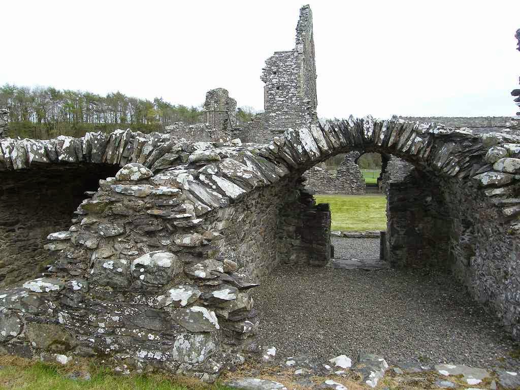
 We visited
Glenluce Abbey on a different day because there wasn’t time on the Walk. It is a 13th century Cistercian
abbey, but the chapter house was built later, around 1500.
We visited
Glenluce Abbey on a different day because there wasn’t time on the Walk. It is a 13th century Cistercian
abbey, but the chapter house was built later, around 1500.
 We got in free
with our ‘English Heritage’ cards. There
is not much of it left — we were glad we didn’t have to pay £4 each to get
in! The lady warden was very pleasant,
and we had a lot of chat.
We got in free
with our ‘English Heritage’ cards. There
is not much of it left — we were glad we didn’t have to pay £4 each to get
in! The lady warden was very pleasant,
and we had a lot of chat.
The chapter house has been restored, and the acoustics in there are most strange. Quiet sounds are amplified as they echo off the walls. It was weird, but great fun!
Location: New England Bay to Glenluce.
Distance: 16 miles.
Total distance: 2853 miles.
Terrain: A lot of beach, much of which was stony and therefore not easy walking. A field, which ended with us climbing a barbed wire fence and wall into a wood, and scrambling down a twelve-foot cliff at the end! A lot of road-walking, some quite busy. We ended by crossing a swampy golf course, getting lost, then a nice path through trees by the river. The sting in the tail was that we reached the road bridge over the river but there was no way up to it! So we climbed over a fence, scrambled up a steep bank through hawthorn bushes and stepped over the Armco. A challenging Walk!
Tide: Coming in, then going out.
Rivers: No.344, Piltanton Burn. No.345, Water of Luce.
Ferries: None.
Piers: None.
Kissing gates: None.
Pubs: None.
‘Historic Scotland’ properties: No.31, Glenluce Abbey.
Ferris wheels: None.
Diversions: None.
How we got there and back: We were staying in our caravan on a site at New England Bay on the South Rhins. This morning Colin drove to Glenluce where he parked at the edge of the town. He then caught a bus to Stranraer which linked up (no thanks to ‘Traveline’ who had told us the wrong place!) with a bus to Ardwell. He alighted at a road junction about a mile from the caravan site, and walked the rest. We started the Walk from the caravan.
At the end I waited near the road junction just across the river while Colin nipped into the edge of town to fetch the car. We then drove back to New England Bay.
The next day we moved the caravan to Garlieston.
We came to the gate at the end, but that proved to be no-go. Not only did it have barbed wire along the top, but there were thick gorse bushes pressed up behind it — it obviously hadn’t been opened for years. So we shuffled along a bit to where there were no gorse bushes and carefully climbed over a single strand of barbed wire and a wall into a wood.
The road was horrible — quite a bit of traffic and it didn’t slow down when it saw us. We were alongside the beach, and the stone situation seemed to improve. We decided it was the lesser of two evils, so where the road branched away by a cottage we returned to the beach.
The tide was coming in quite fast and there was much less beach to walk on now. We came to a long concrete step past a cottage, and found that was much easier to walk on. All was going well until I trod on a wet bit — it was like ice! My foot slipped down about eighteen inches to a lower level — quick as you like! Fortunately I landed on it absolutely square. It gave me a shock, but there was no harm done. We’d both had visions of me breaking my leg again, and I had to rest a few minutes to compose myself. I was very careful after that, but I found myself disliking the beach even more.
We approached Sandhead. We met two women out walking their dog, and stopped to chat. They told us it was a ‘rescue’ dog which was very tentative in water, so they were trying to get it to feel more comfortable on beach walks.
We walked into Sandhead where we saw a tea shop — that’s more like it! It was open six days a week, CLOSED ON TUESDAYS — Aaaaaaaaarrrgh!! (Obviously not our day!)
We continued along the beach, but we didn’t want to go too far because we knew we would get stuck on a marsh and an Army bombing range if we did. So we walked through the caravan site towards its entrance. There we found a path off to the side which looked as if it might go along the back of the beach, but it didn’t — it just led us back to where we’d been before. We retraced our steps and walked out on to the road once again. We were on a B-road, just, and most of the traffic stuck to the A-road which led to Stranraer. But what little traffic did come past us came fast because the road was straight.
Then we had to brave the main road — the A75 main route from the M6 to the port of Stranraer. Horrid! But at least we were able to stay on the grass verge. We were amused to pass a gentleman’s suit caught on the barbed wire fence by the side of the road! We reckoned it had been on a hanger inside a car, and the driver had opened the window because it was a hot day. I wonder how he coped at his business meeting when he found it was missing!
There was a river which we couldn’t cross on the beach, but according to the map a footpath led over a creek and alongside the river back to the main road where we would be able to cross it.
That ended Walk no.288, we shall pick up Walk no.289 next time at the crossroads just south of Glenluce. It was ten past seven, so the Walk had taken us nine hours and five minutes. I waited by the road junction while Colin nipped into the edge of Glenluce to collect the car which he had parked there this morning. We drove back to our caravan at New England Bay where we had our tea and biscuits.
The next day we moved the caravan to Garlieston.
Glenluce Abbey
The chapter house has been restored, and the acoustics in there are most strange. Quiet sounds are amplified as they echo off the walls. It was weird, but great fun!

1 comment:
Great blog.I enjoyed reading this post.You are a great inspiration to other folk who want to enjoy the outdoors.Keep it up,greetings from Malta.
Post a Comment