Weather: Bright with some sun. There was a cold breeze in exposed places,
and a sea mist for the last two miles.
Location: Portpatrick to Port Logan.
Distance: 14 miles.
Total distance: 2827 miles.
Terrain: The cliff path took us further than we expected because it wasn’t marked on the map. Quiet roads mostly. A track which deteriorated — it was blocked by electric fences, mud and gorse!
Tide: In.
Rivers: None.
Ferries: None.
Piers: None.
Kissing gates: Nos.263 to 272, from above Moroch Bay to an hotel.
Pubs: None.
‘Historic Scotland’ properties: None.
Ferris wheels: None.
Diversions: None.
How we got there and back: We were staying in our caravan on a site at New England Bay on the South Rhins. This morning we drove to Port Logan and parked in the seafront car park. We caught a bus from the hamlet to Lochans. There we had to wait half an hour before catching another bus from the opposite side of the road to Portpatrick.
At the end we were at the car. We drove back to our caravan at New England Bay where we had our tea and biscuits.

We started by walking along the waterfront in Portpatrick, passing a memorial bench to John and Mary McDowall. Their epitaph read, “It’s bein’ sae cheerful that keeps us goin’”! I like them already! (Though I never met them during their lifetime, nor know anything about them.)
 Next we passed a shop which sold all sorts of
oddities. Two days ago there was a large
gorilla outside, today it was an Easter Island
statue! It looked so out of place in
this delightful little Scottish harbour town.
Besides, the mouth on the moai didn’t look right to us — we, who have
been to Rapa Nui and seen the real thing. Too much of a smile on this one, and the rock
it was carved from was the wrong colour — they appear to have used granite
whereas the genuine moai were carved from solidified volcanic ash.
Next we passed a shop which sold all sorts of
oddities. Two days ago there was a large
gorilla outside, today it was an Easter Island
statue! It looked so out of place in
this delightful little Scottish harbour town.
Besides, the mouth on the moai didn’t look right to us — we, who have
been to Rapa Nui and seen the real thing. Too much of a smile on this one, and the rock
it was carved from was the wrong colour — they appear to have used granite
whereas the genuine moai were carved from solidified volcanic ash.
 We moved on past this nonsense (who on earth would
want a moai in their garden anyhow?) to the lighthouse on the southern
extremity of the harbour. Portpatrick
looked very pretty in the morning light.
We moved on past this nonsense (who on earth would
want a moai in their garden anyhow?) to the lighthouse on the southern
extremity of the harbour. Portpatrick
looked very pretty in the morning light.

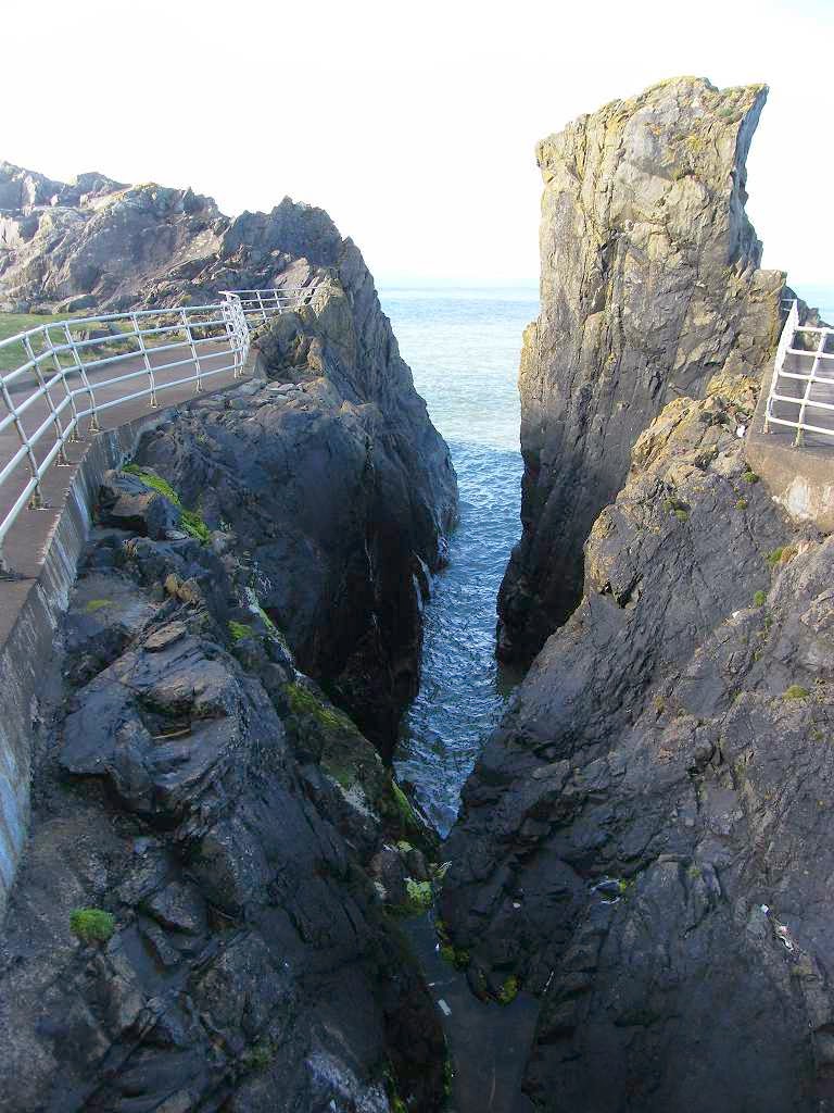 We continued southwards to a car park in an old quarry, and from there
we gradually climbed. There was a deep
cleft in the cliff at the end of the car park which was surrounded by stout
fencing to stop people driving their cars into it.
We continued southwards to a car park in an old quarry, and from there
we gradually climbed. There was a deep
cleft in the cliff at the end of the car park which was surrounded by stout
fencing to stop people driving their cars into it.
A narrow path led to the top of the cliff and along. To our right was the sharp drop down to the sea, and to our left was another sharp drop down to a disused railway line. We seemed to be walking along a knife-edge! But luckily, to the relief of anyone suffering from vertigo, the trail was enclosed in good strong fencing either side.
 It was quite cool
in the wind up there, but we came across a sheltered seat so we sat on it to
eat our quiche/pasty.
It was quite cool
in the wind up there, but we came across a sheltered seat so we sat on it to
eat our quiche/pasty.

 We met a lot of people on this narrow part of the
path. Most were commenting on the deep
cutting which used to take the rock out from the quarry by train, and the even
deeper clefts in the cliff on the other side.
We came to a ruin, named ‘Dunskey
Castle’ in ancient
lettering on our map. Apparently it has
been a ruin since the 17th century.
We met a lot of people on this narrow part of the
path. Most were commenting on the deep
cutting which used to take the rock out from the quarry by train, and the even
deeper clefts in the cliff on the other side.
We came to a ruin, named ‘Dunskey
Castle’ in ancient
lettering on our map. Apparently it has
been a ruin since the 17th century.
 Why do we keep these buildings?
There are too many useless little ruins along the coastline to warrant
spending taxpayers money on them. Keep
the big ones for their historical significance and as tourist attractions, but
why little ones like this? Let them fall
down, I say, or use the stone for building new homes, as our forefathers did.
Why do we keep these buildings?
There are too many useless little ruins along the coastline to warrant
spending taxpayers money on them. Keep
the big ones for their historical significance and as tourist attractions, but
why little ones like this? Let them fall
down, I say, or use the stone for building new homes, as our forefathers did.
The path took us up to a caravan site where we thought we would have to continue inland until we hit the road. There were no further paths marked on our map along the coast. But there was a signpost telling us we could get to Morroch Bay, and we could see a good path snaking away across the cliff tops.
 We were delighted, and wondered how far we would get before we had to
retreat to the road.
We were delighted, and wondered how far we would get before we had to
retreat to the road.

 It was a lovely walk along that rocky coast. The views were spectacular, with many nooks
and crevices on the edge of the cliffs. And
it was a good path all the way.
It was a lovely walk along that rocky coast. The views were spectacular, with many nooks
and crevices on the edge of the cliffs. And
it was a good path all the way.
 Also
there were primroses all about — I love their delicate shade of yellow in the
springtime! The further from Portpatrick
we progressed, the less people we encountered.
Soon we were completely on our own, and we didn’t meet any other walkers
all the way to Port Logan.
Also
there were primroses all about — I love their delicate shade of yellow in the
springtime! The further from Portpatrick
we progressed, the less people we encountered.
Soon we were completely on our own, and we didn’t meet any other walkers
all the way to Port Logan.
 We reached Morroch Bay,
and were pleased we didn’t have to go down to the beach there — we would only
have had to climb back up again! There
were kissing gates all round the top of the bay, lots of them and all spanking
new. So efforts are being made to put in
more of a coastal path.
We reached Morroch Bay,
and were pleased we didn’t have to go down to the beach there — we would only
have had to climb back up again! There
were kissing gates all round the top of the bay, lots of them and all spanking
new. So efforts are being made to put in
more of a coastal path.
 We came to a
road up from a house in the bay. A man
drove up and had to get out of his car to open a gate. We arrived just then, so Colin closed it for
him to save him getting out again after he had passed through.
We came to a
road up from a house in the bay. A man
drove up and had to get out of his car to open a gate. We arrived just then, so Colin closed it for
him to save him getting out again after he had passed through.
We thought we had come to the end of the new path and would have to follow this private road up to the public road from that point. But there was another kissing gate on the opposite side of the road, so we carried on.
 The path was not so clear now, the only way
we could tell where it went was to look for the location of the next kissing
gate. This trail was obviously not well
walked. We were led down a steep hill
into a gully — this part of the path looked very new. Arrows had not yet been put on the posts
though the hollows for them were there, and the earth had recently been
scrubbed out to make the path.
The path was not so clear now, the only way
we could tell where it went was to look for the location of the next kissing
gate. This trail was obviously not well
walked. We were led down a steep hill
into a gully — this part of the path looked very new. Arrows had not yet been put on the posts
though the hollows for them were there, and the earth had recently been
scrubbed out to make the path.
Location: Portpatrick to Port Logan.
Distance: 14 miles.
Total distance: 2827 miles.
Terrain: The cliff path took us further than we expected because it wasn’t marked on the map. Quiet roads mostly. A track which deteriorated — it was blocked by electric fences, mud and gorse!
Tide: In.
Rivers: None.
Ferries: None.
Piers: None.
Kissing gates: Nos.263 to 272, from above Moroch Bay to an hotel.
Pubs: None.
‘Historic Scotland’ properties: None.
Ferris wheels: None.
Diversions: None.
How we got there and back: We were staying in our caravan on a site at New England Bay on the South Rhins. This morning we drove to Port Logan and parked in the seafront car park. We caught a bus from the hamlet to Lochans. There we had to wait half an hour before catching another bus from the opposite side of the road to Portpatrick.
At the end we were at the car. We drove back to our caravan at New England Bay where we had our tea and biscuits.
We started by walking along the waterfront in Portpatrick, passing a memorial bench to John and Mary McDowall. Their epitaph read, “It’s bein’ sae cheerful that keeps us goin’”! I like them already! (Though I never met them during their lifetime, nor know anything about them.)
A narrow path led to the top of the cliff and along. To our right was the sharp drop down to the sea, and to our left was another sharp drop down to a disused railway line. We seemed to be walking along a knife-edge! But luckily, to the relief of anyone suffering from vertigo, the trail was enclosed in good strong fencing either side.
The path took us up to a caravan site where we thought we would have to continue inland until we hit the road. There were no further paths marked on our map along the coast. But there was a signpost telling us we could get to Morroch Bay, and we could see a good path snaking away across the cliff tops.
We thought we had come to the end of the new path and would have to follow this private road up to the public road from that point. But there was another kissing gate on the opposite side of the road, so we carried on.

We were resigned, by now, to walking miles of road practically all the rest of the way to Port Logan. We started up the hotel road. Further on there was another kissing gate on the other side of the road. Could it possibly be a continuation of the coastal path? There were no signs, and the gate looked very new. A glance at the map told us there were no further ways out to the road for miles and miles. Considering the state of that last bit of path down into the gully, we decided we daren’t risk it. We still had a long way to go and we didn’t want to get lumbered. So we ignored it and continued up the road.


It was farming country — we noted a Shetland pony in a field with chickens, celandines all over the grass banks, three modern windmills on a hill, and a horse wearing a coat sitting down in a field.

I thought horses only sat down when they were ill — we did wonder about this animal…..


After passing a Flowerpot Man doing his skiing exercises (at least, that’s what it looked like!) we saw some hares on the grass up ahead. Colin hadn’t got his camera handy, so I whipped mine out and managed one photo before they darted into the undergrowth.


Further on we sat on a roadside bank again to eat our apples.
We walked under a rookery where the road was spotted with their droppings — but none landed on us as we passed through! We passed a rather pretty house, which looked very neat but had chickens roaming about on its lawns.


Or were we? We searched the map to find Drumbreddan and discovered we hadn’t got there yet! It was a farm about half a mile ahead. Port Logan, our destination, was even further on. Very puzzling. We got to the farm, but we couldn’t see our way on from there. The farmyard was full of cows, and that seemed to be the only route onwards — but then Colin found an almost hidden gate to the side with a muddy track leading away from it. No signpost of any kind.


We walked to the end of the field and came across another of those puzzling signposts. This one was pointing back the way we had come, and told us “Footpath Drumbreddan to Ardwell Bay”. We were at least half a mile beyond Drumbreddan by then! Turning to our way, we found we had to negotiate a gate choked by gorse.


That ended Walk no.286, we shall pick up Walk no.287 next time at the car park in Port Logan. It was twenty-five to six, so the Walk had taken us eight hours and twenty minutes. We drove back to our caravan at New England Bay where we had our tea and biscuits in the warm and dry.

No comments:
Post a Comment