Ages: Colin was 69 years and 344 days. Rosemary was 67 years and 121 days.
Weather: Brilliant sunshine but a cold wind. Becoming overcast, but the rain held off
until the Walk was over.
Location: Garlieston to Newton Stewart.
Distance: 21 miles.
Total
distance: 2914 miles.
Terrain: Tiny bit
of beach. A lovely path through bluebell
woods. A few tracks and a lot of
road. A cycle-path at the end. Mostly flat.
Tide: Coming in.
Rivers: No.347,
River Bladnoch. No.348, Bishop
Burn. No.349, Brushy Burn.
Ferries: None.
Piers: None.
Kissing
gates: Nos.298 & 299 at the bowling green in
Garlieston. Nos.300 to 303 in the
bluebell wood.
Pubs: We stopped at the Bladnoch Inn, but it wasn’t
a ‘real ale’ pub though it advertised itself as such.
‘Historic Scotland’ properties: None.
Ferris wheels: None.
Diversions: None.
How we got there and
back: We were staying in our caravan on
a site in Garlieston. Early this morning
Colin drove the car to Newton Stewart where he parked just beyond the
roundabout. He caught a bus back to
Garlieston, then he had his breakfast!
At the end we were at the
car. We drove straight back to
Garlieston for tea and biscuits in the caravan.
We left the caravan site and walked through Garlieston
along the waterfront. We passed a
polished granite stone commemorating the mulberry harbours which were made and
tested here. What a clever tactic! The mulberry harbours had to be constructed
in complete secrecy because they would have been useless if the Germans had
caught even a whiff of what was going on, and D-Day would never have
happened.
So they were constructed in
this quiet corner of Scotland,
hundreds of miles from where they were going to be used. The wording on the stone reads: 1945 – 1995
For the 50th anniversary of the end of World War II this
commemorates the building and trials of Sections of the “MULBERRY
HARBOUR 1941/4” at GARLIESTON, thus
making the INVASION OF EUROPE possible and the
ALLIED VICTORY a reality.
We were
amused by a car park notice nearby which read: “No boats or trailers”. There were no cars parked there, just a boat
on a trailer! We walked past the bowling green and the War
Memorial. Everywhere we go we are
reminded how the two World Wars of the 20th century decimated
families and changed lives forever.
Today children were hurrying to school, for it is the first day of the
summer term.
There is a small waterwheel by the stream which
leads into Garlieston
Bay, but it wasn’t
working. All around the adjacent walls
there were large sculptures of insects made out of odd bits of metal — they
were brilliantly designed. We liked the
dragonfly which was attached to the back wall the best!
The tide was out enough for us to walk across the
sand, which we did for a bit. But it
soon turned to slimey green rocks, so we had to return to the road. Garlieston
Bay looked lovely in the
early morning sun.
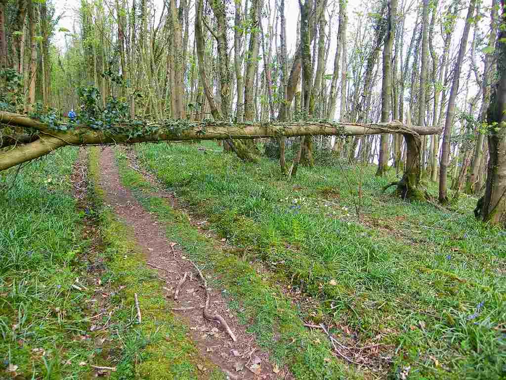
The road turned into
a track, and then into a footpath signposted “Innerwell 3m”. That footpath was the best bit of the whole
Walk! It led through woods with dappled
sun shining through the trees which hadn’t yet quite got their leaves. There were bluebells, wood anemones,
primroses, and other Spring flowers everywhere.
And to our right we kept catching glimpses of the sea through the trees, and
Garlieston across the bay.
It was beautiful !
It even smelt
beautiful, as woodland has a wonderful gentle aroma especially in the
springtime.
Magical!
We came out of the woods, and there was a bit of a
dodgy path along the edge of a field. We
got the impression the farmer had tried to obliterate it.
But we coped, and soon we were back in the
woods where everything was gorgeous again.
We sat on a log to eat our pizza / pie.
A blister on my heel started giving me trouble again. I had already put a plaster over it, so I
took some painkillers and had no more trouble.
We came out on a tarmacked lane at Innerwell. We had hoped there would be a new footpath,
not marked on the map, leading us further along the coast. But there wasn’t, so we had to walk inland a
mile along the lane until we reached the road.
We passed a lot of what I call ‘plastic farming’. Fields are covered in plastic to form
cloches, and it looks horrible! But I suppose they have to do it to feed the
masses — don’t think it does much for wildlife though.
We donned our bright yellow waistcoats. Traffic was infrequent, but the road was
pretty straight so when it came it was fast! We sat on a stone in the edge of a wood to
eat our sarnies. After two miles we were
able to turn off on to a quieter road.
I had calculated that we had walked 2900 miles from
Bognor, so we needed to take a photograph.
There was no one about to ask, so we placed the camera on a fencepost
and took it on the 10 second timer. It
came out quite well!
The lane we had turned on to took us through a farm,
past a caravan site and then it turned into a track. There we met a woman who was hitching up a
horsebox to her 4x4. She was finding it
tricky so we offered to help. She turned
us down because of “health & safety issues”! What has this world come to that you cannot
even lend a hand (my Brownie motto of 60 years ago, if I remember rightly)
because people are afraid of being sued if it all goes wrong? Bemused, we left her to her exertions and
continued along the track.
It was a pleasant walkway which led us towards
Wigtown. We came to a T-junction where
we wanted to turn right because it looked as if that would be the way to
Wigtown. But a quick look at the map
confirmed that it led into a nature reserve, and it was a dead end because
there is no way to cross the river which winds around the town. So we turned left which took us inland again. A simple footbridge on the edge of the nature
reserve would have saved us miles!
There was an airfield marked on the map, and we
didn’t know if it was still in use or not.
I thought I saw a small aeroplane through the bushes, but when we got
nearer it turned out it was a boat on a trailer! (Colin laughed) The airfield was completely grassed over, it
obviously hadn’t been in use for many years.
But the OS map we were using was new,
only bought a few weeks previously. I do
wish the Ordnance Survey would get their maps up to date — they charge enough
for them!
We walked about a mile and a half until we came to a
broken bridge over the lane — remnant of a disused railway line. From there we skirted round the edge of the
old airfield. It was a roundabout route,
and Colin kept on about taking a shortcut.
I hate walking on roads too, but the trouble with short cuts is that
they inevitably end at a hedge, a ditch or a barbed wire fence. So I refused to turn off the road — at least
we knew we could get through. The truth
was we were both tired and getting grouchy.
We met a couple out on hire-bikes, they didn’t look
like regular cyclists. They seemed to be
tired and grouchy too, especially the woman.
The lane we were on wound round next to the river, and eventually went
under a bridge (which was still there) of the disused railway. This one had a barn on top!
Through the trees we could see the pillars
which once held up the railway over the river.
A quarter of a mile further on we came to the main road where the only
bridge across the river was situated. At
last we were able to cross it!
We had already walked twelve miles and we were tired
and cross. So when we saw a pub which
advertised ‘real ales’ we couldn’t believe our luck! And it
was open. But there were no taps inside,
the ‘real ale’ was in bottles! The
barmaid said they had run out because they had just had “a very busy
weekend”. Colin asked her what he had
missed, and she quoted ales that aren’t bottle-conditioned. She obviously knew nothing about it at all.
Anyhow, my shandy was very welcome, and we both felt better after a
drink and a rest.
Up the road we sat on a seat and ate chocolate. We turned into a farm road, then went down
across the disused railway again, and took a track to Wigtown Harbour Road. It was a good path across the top of the
harbour which is now all marsh and a nature reserve.
Back in the 17th century things were very
different in Wigtown. High tides brought
the water right up to the town over what is now marshes. There was also a lot of religious intolerance. In 1685 two women, Margaret McLachlan, who
was in her sixties, and Margaret Wilson, who was only eighteen years old, were
arrested for being ‘Covenanters’, a movement that maintained the reforms of the
Scottish Reformation. They refused to
recant, so they were tied to stakes below high tide mark so that they would
drown as the water came in. The older
woman was tied further down the beach so that the younger woman would see her
suffering as she drowned, whereby it was hoped that she would change her
mind. She didn’t, and both women
drowned. Such was the state of religious
prejudice in those times. With our
history and murders such as these, we cannot take on a ‘holier than thou’
attitude when we hear of present-day religious persecution in other countries.

There is a boardwalk across the marshes
leading out to a memorial stake, in memory of those two brave women.
We came out on to a lane with still about five or
six miles to walk before we got to Newton Stewart. It was a long long road, but fortunately very
quiet — we were passed by only half a dozen vehicles over the next two hours. We sat by a river out of the wind to eat our
apples.
Then we marched on, making good
time because it was so boring. The road
was very straight, and there was nothing to see except farmland.
We watched tractors working in the fields followed
by gulls. We were amused by a “Danger of
Death” notice on a fencepost which had been put in upside down.
We saw some sheep’s wool caught around the
flowers of a dandelion plant. And we
were mildly amused by a property called ‘Polwhilly’. Really, we were just looking around for
things to relieve the tedium of walking along a straight and featureless road.
After about an hour we passed a cottage with an Easter Island statue in the garden. (We wondered if it had been bought in that
shop in Portpatrick.)
Then we saw a huge
white rabbit behind the house. In the
woods there was a scantily clad Greek goddess-type woman, and there were flags
up in the trees. Definitely a boring
road — either that or we were going mad!
We sat by another river and ate more chocolate. We met a pleasant young woman out walking her
dog who stopped for a chat. She was most
interested in our trek, so I gave her a blog card. (Are you still reading it?) The sky was quite grey and gloomy by now, but
the rain held off.
Eventually we came to the main road, but we still had
two miles to go before we reached Newton Stewart. However, there was a cycleway next to the
road so we didn’t have to dodge the traffic.
The sting in the tail was that the cycleway didn’t go all the way to the
roundabout where our car was parked, but veered away about a quarter of a mile
earlier to go under the main A75 by the river.
It doesn’t connect up with the road we were on until it is well into the
town, and we didn’t realise this until we had walked almost to the tunnel
underneath the A75. So we had to
backtrack until we found a steep stony track which took us back up to the
road. Fortunately there was a pavement
between there and the roundabout, so we still didn’t have to dodge the traffic —
only when crossing the road at the roundabout.
Our car was parked in a nearby Close.
That ended Walk no.291, we shall pick up Walk no.292
next time at the roundabout just to the south-west of Newton Stewart. It was quarter-past seven, so the Walk had
taken us ten and three-quarter hours. We
got in the car and it started to rain — what timing! So we drove straight back to the caravan in
Garlieston and had our tea and biscuits there.


 We saw some sheep’s wool caught around the
flowers of a dandelion plant. And we
were mildly amused by a property called ‘Polwhilly’. Really, we were just looking around for
things to relieve the tedium of walking along a straight and featureless road.
We saw some sheep’s wool caught around the
flowers of a dandelion plant. And we
were mildly amused by a property called ‘Polwhilly’. Really, we were just looking around for
things to relieve the tedium of walking along a straight and featureless road.
 Then we saw a huge
white rabbit behind the house. In the
woods there was a scantily clad Greek goddess-type woman, and there were flags
up in the trees. Definitely a boring
road — either that or we were going mad!
Then we saw a huge
white rabbit behind the house. In the
woods there was a scantily clad Greek goddess-type woman, and there were flags
up in the trees. Definitely a boring
road — either that or we were going mad!
No comments:
Post a Comment